You are here: Home > Network List > TA - USArray Transportable Network (new EarthScope stations) Stations List
> Station O30N Mendenhall, YT, Canada > Earthquake Result Viewer
O30N Mendenhall, YT, Canada - Earthquake Result Viewer
| Earthquake location: |
Solomon Islands |
| Earthquake latitude/longitude: |
-10.3/161.5 |
| Earthquake time(UTC): |
2017/08/06 (218) 00:15:10 GMT |
| Earthquake Depth: |
73 km |
| Earthquake Magnitude: |
5.7 Mww |
| Earthquake Catalog/Contributor: |
NEIC PDE/us |
|
| Network: |
TA USArray Transportable Network (new EarthScope stations) |
| Station: |
O30N Mendenhall, YT, Canada |
| Lat/Lon: |
60.77 N/136.09 W |
| Elevation: |
821 m |
|
| Distance: |
86.0 deg |
| Az: |
25.857 deg |
| Baz: |
240.992 deg |
| Ray Param: |
0.044204604 |
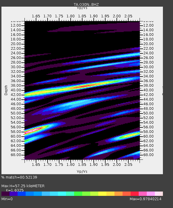
| Estimated Moho Depth: |
57.25 km |
| Estimated Crust Vp/Vs: |
1.63 |
| Assumed Crust Vp: |
6.566 km/s |
| Estimated Crust Vs: |
4.022 km/s |
| Estimated Crust Poisson's Ratio: |
0.20 |
|
| Radial Match: |
80.52139 % |
| Radial Bump: |
400 |
| Transverse Match: |
57.53179 % |
| Transverse Bump: |
400 |
| SOD ConfigId: |
13570011 |
| Insert Time: |
2019-04-28 13:02:56.687 +0000 |
| GWidth: |
2.5 |
| Max Bumps: |
400 |
| Tol: |
0.001 |
|

Signal To Noise
| Channel | StoN | STA | LTA |
| TA:O30N: :BHZ:20170806T00:27:11.450015Z | 2.4682753 | 1.5936627E-7 | 6.456584E-8 |
| TA:O30N: :BHN:20170806T00:27:11.450015Z | 1.0147687 | 4.1202444E-8 | 4.0602792E-8 |
| TA:O30N: :BHE:20170806T00:27:11.450015Z | 2.1687098 | 8.038074E-8 | 3.7063852E-8 |
| Arrivals |
| Ps | 5.7 SECOND |
| PpPs | 22 SECOND |
| PsPs/PpSs | 28 SECOND |


