You are here: Home > Network List > UW - Pacific Northwest Regional Seismic Network Stations List
> Station LON Longmire CREST broad-band > Earthquake Result Viewer
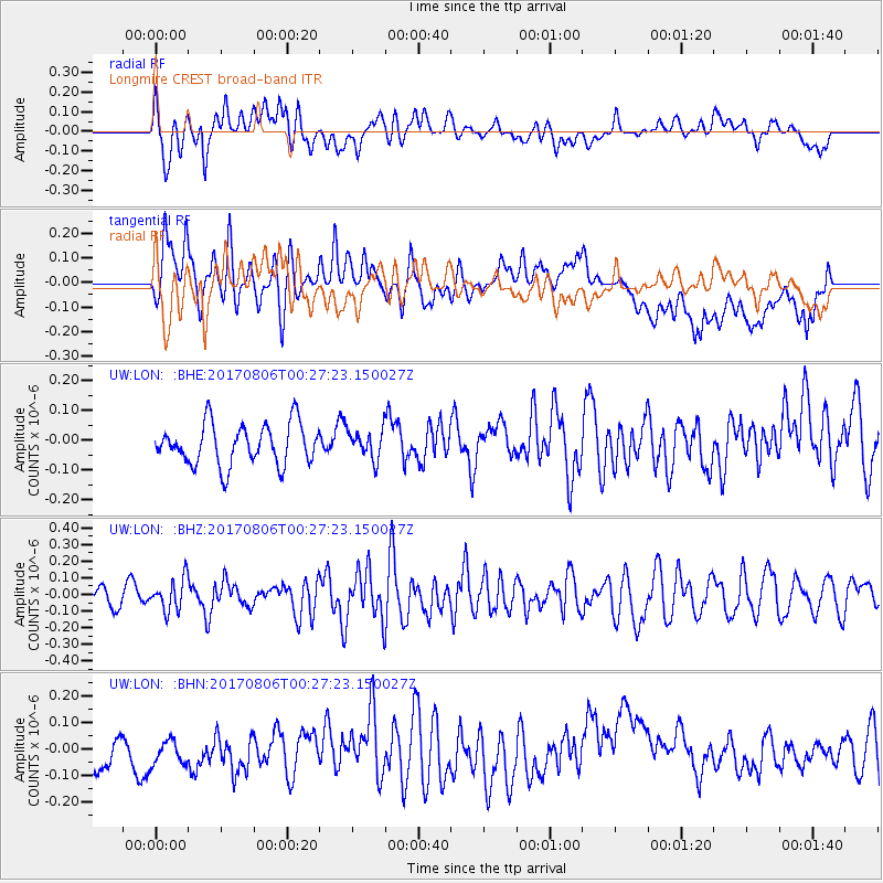
LON Longmire CREST broad-band - Earthquake Result Viewer
*The percent match for this event was below the threshold and hence no stack was calculated.
| Earthquake location: |
Solomon Islands |
| Earthquake latitude/longitude: |
-10.3/161.5 |
| Earthquake time(UTC): |
2017/08/06 (218) 00:15:10 GMT |
| Earthquake Depth: |
73 km |
| Earthquake Magnitude: |
5.7 Mww |
| Earthquake Catalog/Contributor: |
NEIC PDE/us |
|
| Network: |
UW Pacific Northwest Regional Seismic Network |
| Station: |
LON Longmire CREST broad-band |
| Lat/Lon: |
46.75 N/121.81 W |
| Elevation: |
853 m |
|
| Distance: |
88.5 deg |
| Az: |
42.025 deg |
| Baz: |
253.375 deg |
| Ray Param: |
$rayparam |
*The percent match for this event was below the threshold and hence was not used in the summary stack. |
|
| Radial Match: |
58.044983 % |
| Radial Bump: |
400 |
| Transverse Match: |
44.70553 % |
| Transverse Bump: |
400 |
| SOD ConfigId: |
13570011 |
| Insert Time: |
2019-04-28 13:03:35.979 +0000 |
| GWidth: |
2.5 |
| Max Bumps: |
400 |
| Tol: |
0.001 |
|
Signal To Noise
| Channel | StoN | STA | LTA |
| UW:LON: :BHZ:20170806T00:27:23.150027Z | 1.7809889 | 9.658794E-8 | 5.4232757E-8 |
| UW:LON: :BHN:20170806T00:27:23.150027Z | 0.7763758 | 7.4965236E-8 | 9.6557926E-8 |
| UW:LON: :BHE:20170806T00:27:23.150027Z | 0.67425436 | 4.6058663E-8 | 6.831052E-8 |
| Arrivals |
| Ps | |
| PpPs | |
| PsPs/PpSs | |


