You are here: Home > Network List > TA - USArray Transportable Network (new EarthScope stations) Stations List
> Station H25A Fruitdale, SD, USA > Earthquake Result Viewer
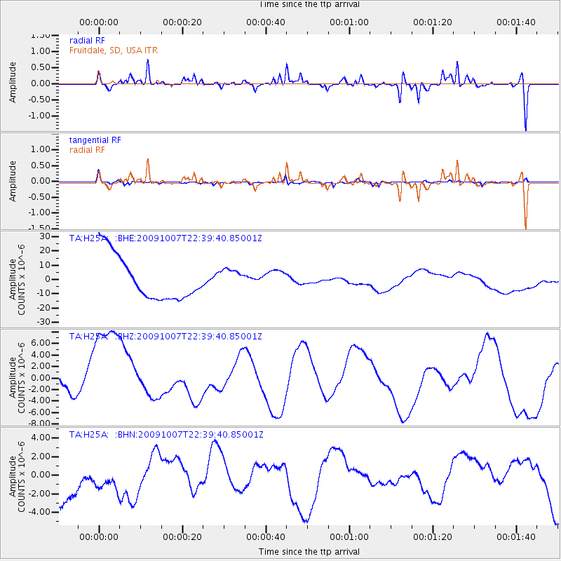
H25A Fruitdale, SD, USA - Earthquake Result Viewer
*The percent match for this event was below the threshold and hence no stack was calculated.
| Earthquake location: |
Santa Cruz Islands |
| Earthquake latitude/longitude: |
-12.1/166.6 |
| Earthquake time(UTC): |
2009/10/07 (280) 22:26:38 GMT |
| Earthquake Depth: |
35 km |
| Earthquake Magnitude: |
5.6 MB |
| Earthquake Catalog/Contributor: |
WHDF/NEIC |
|
| Network: |
TA USArray Transportable Network (new EarthScope stations) |
| Station: |
H25A Fruitdale, SD, USA |
| Lat/Lon: |
44.62 N/103.60 W |
| Elevation: |
942 m |
|
| Distance: |
98.2 deg |
| Az: |
46.179 deg |
| Baz: |
261.192 deg |
| Ray Param: |
$rayparam |
*The percent match for this event was below the threshold and hence was not used in the summary stack. |
|
| Radial Match: |
74.76148 % |
| Radial Bump: |
387 |
| Transverse Match: |
66.49898 % |
| Transverse Bump: |
331 |
| SOD ConfigId: |
2622 |
| Insert Time: |
2010-03-06 02:35:05.609 +0000 |
| GWidth: |
2.5 |
| Max Bumps: |
400 |
| Tol: |
0.001 |
|
Signal To Noise
| Channel | StoN | STA | LTA |
| TA:H25A: :BHZ:20091007T22:39:40.85001Z | 3.4424691 | 9.88629E-6 | 2.8718603E-6 |
| TA:H25A: :BHN:20091007T22:39:40.85001Z | 0.756134 | 2.2270026E-6 | 2.9452488E-6 |
| TA:H25A: :BHE:20091007T22:39:40.85001Z | 0.46155557 | 7.0659835E-6 | 1.5309064E-5 |
| Arrivals |
| Ps | |
| PpPs | |
| PsPs/PpSs | |


