You are here: Home > Network List > TA - USArray Transportable Network (new EarthScope stations) Stations List
> Station H25A Fruitdale, SD, USA > Earthquake Result Viewer
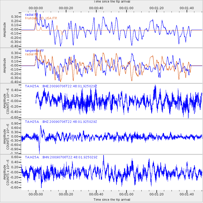
H25A Fruitdale, SD, USA - Earthquake Result Viewer
*The percent match for this event was below the threshold and hence no stack was calculated.
| Earthquake location: |
Southeast Of Ryukyu Islands |
| Earthquake latitude/longitude: |
24.9/128.0 |
| Earthquake time(UTC): |
2009/07/06 (187) 22:35:05 GMT |
| Earthquake Depth: |
10 km |
| Earthquake Magnitude: |
6.1 MB, 5.3 MS, 5.7 MW, 5.7 MW |
| Earthquake Catalog/Contributor: |
WHDF/NEIC |
|
| Network: |
TA USArray Transportable Network (new EarthScope stations) |
| Station: |
H25A Fruitdale, SD, USA |
| Lat/Lon: |
44.62 N/103.60 W |
| Elevation: |
942 m |
|
| Distance: |
96.3 deg |
| Az: |
34.281 deg |
| Baz: |
314.24 deg |
| Ray Param: |
$rayparam |
*The percent match for this event was below the threshold and hence was not used in the summary stack. |
|
| Radial Match: |
55.058876 % |
| Radial Bump: |
400 |
| Transverse Match: |
47.18818 % |
| Transverse Bump: |
400 |
| SOD ConfigId: |
2648 |
| Insert Time: |
2010-03-06 02:35:08.341 +0000 |
| GWidth: |
2.5 |
| Max Bumps: |
400 |
| Tol: |
0.001 |
|
Signal To Noise
| Channel | StoN | STA | LTA |
| TA:H25A: :BHZ:20090706T22:48:01.925029Z | 3.7238224 | 3.9760516E-7 | 1.0677339E-7 |
| TA:H25A: :BHN:20090706T22:48:01.925029Z | 1.291616 | 2.0236857E-7 | 1.5667858E-7 |
| TA:H25A: :BHE:20090706T22:48:01.925029Z | 1.3894289 | 2.3013689E-7 | 1.6563418E-7 |
| Arrivals |
| Ps | |
| PpPs | |
| PsPs/PpSs | |


