You are here: Home > Network List > TA - USArray Transportable Network (new EarthScope stations) Stations List
> Station H26A Fairpoint, SD, USA > Earthquake Result Viewer
H26A Fairpoint, SD, USA - Earthquake Result Viewer

| Earthquake location: |
Off Coast Of Costa Rica |
| Earthquake latitude/longitude: |
7.9/-85.6 |
| Earthquake time(UTC): |
2009/08/13 (225) 09:37:35 GMT |
| Earthquake Depth: |
10 km |
| Earthquake Magnitude: |
5.8 MW, 5.3 MB |
| Earthquake Catalog/Contributor: |
WHDF/NEIC |
|
| Network: |
TA USArray Transportable Network (new EarthScope stations) |
| Station: |
H26A Fairpoint, SD, USA |
| Lat/Lon: |
44.62 N/102.77 W |
| Elevation: |
879 m |
|
| Distance: |
39.5 deg |
| Az: |
340.656 deg |
| Baz: |
152.652 deg |
| Ray Param: |
0.07497504 |
| Estimated Moho Depth: |
23.75 km |
| Estimated Crust Vp/Vs: |
1.91 |
| Assumed Crust Vp: |
6.242 km/s |
| Estimated Crust Vs: |
3.272 km/s |
| Estimated Crust Poisson's Ratio: |
0.31 |
|
| Radial Match: |
89.31873 % |
| Radial Bump: |
278 |
| Transverse Match: |
55.968773 % |
| Transverse Bump: |
350 |
| SOD ConfigId: |
2622 |
| Insert Time: |
2010-03-06 02:35:16.285 +0000 |
| GWidth: |
2.5 |
| Max Bumps: |
400 |
| Tol: |
0.001 |
|
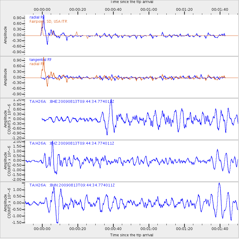
Signal To Noise
| Channel | StoN | STA | LTA |
| TA:H26A: :BHZ:20090813T09:44:34.774011Z | 6.2950053 | 4.1182554E-7 | 6.5421E-8 |
| TA:H26A: :BHN:20090813T09:44:34.774011Z | 4.077337 | 3.1273808E-7 | 7.6701554E-8 |
| TA:H26A: :BHE:20090813T09:44:34.774011Z | 2.1468756 | 1.9267219E-7 | 8.9745384E-8 |
| Arrivals |
| Ps | 3.7 SECOND |
| PpPs | 10 SECOND |
| PsPs/PpSs | 14 SECOND |


