You are here: Home > Network List > TA - USArray Transportable Network (new EarthScope stations) Stations List
> Station H26A Fairpoint, SD, USA > Earthquake Result Viewer
H26A Fairpoint, SD, USA - Earthquake Result Viewer

| Earthquake location: |
East Of Severnaya Zemlya |
| Earthquake latitude/longitude: |
81.6/119.5 |
| Earthquake time(UTC): |
2009/10/07 (280) 20:52:13 GMT |
| Earthquake Depth: |
8.0 km |
| Earthquake Magnitude: |
5.7 MB, 5.1 MS, 5.8 MW, 5.8 MW |
| Earthquake Catalog/Contributor: |
WHDF/NEIC |
|
| Network: |
TA USArray Transportable Network (new EarthScope stations) |
| Station: |
H26A Fairpoint, SD, USA |
| Lat/Lon: |
44.62 N/102.77 W |
| Elevation: |
879 m |
|
| Distance: |
52.1 deg |
| Az: |
37.536 deg |
| Baz: |
352.77 deg |
| Ray Param: |
0.06698633 |
| Estimated Moho Depth: |
14.25 km |
| Estimated Crust Vp/Vs: |
1.69 |
| Assumed Crust Vp: |
6.242 km/s |
| Estimated Crust Vs: |
3.704 km/s |
| Estimated Crust Poisson's Ratio: |
0.23 |
|
| Radial Match: |
84.82959 % |
| Radial Bump: |
400 |
| Transverse Match: |
69.268616 % |
| Transverse Bump: |
400 |
| SOD ConfigId: |
2622 |
| Insert Time: |
2010-03-06 02:35:22.793 +0000 |
| GWidth: |
2.5 |
| Max Bumps: |
400 |
| Tol: |
0.001 |
|
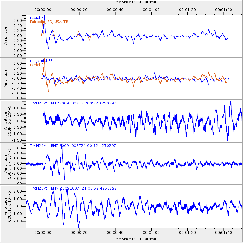
Signal To Noise
| Channel | StoN | STA | LTA |
| TA:H26A: :BHZ:20091007T21:00:52.425029Z | 5.162242 | 9.304058E-7 | 1.802329E-7 |
| TA:H26A: :BHN:20091007T21:00:52.425029Z | 2.2879071 | 9.013323E-7 | 3.9395493E-7 |
| TA:H26A: :BHE:20091007T21:00:52.425029Z | 0.86292326 | 2.3040822E-7 | 2.6700891E-7 |
| Arrivals |
| Ps | 1.7 SECOND |
| PpPs | 5.8 SECOND |
| PsPs/PpSs | 7.5 SECOND |


