You are here: Home > Network List > TA - USArray Transportable Network (new EarthScope stations) Stations List
> Station H26A Fairpoint, SD, USA > Earthquake Result Viewer
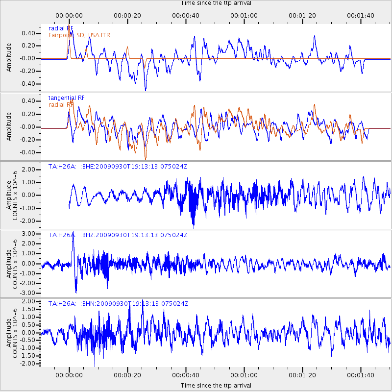
H26A Fairpoint, SD, USA - Earthquake Result Viewer
*The percent match for this event was below the threshold and hence no stack was calculated.
| Earthquake location: |
Peru-Bolivia Border Region |
| Earthquake latitude/longitude: |
-15.6/-69.3 |
| Earthquake time(UTC): |
2009/09/30 (273) 19:03:17 GMT |
| Earthquake Depth: |
255 km |
| Earthquake Magnitude: |
5.9 MB, 5.8 MW |
| Earthquake Catalog/Contributor: |
WHDF/NEIC |
|
| Network: |
TA USArray Transportable Network (new EarthScope stations) |
| Station: |
H26A Fairpoint, SD, USA |
| Lat/Lon: |
44.62 N/102.77 W |
| Elevation: |
879 m |
|
| Distance: |
67.2 deg |
| Az: |
334.697 deg |
| Baz: |
144.773 deg |
| Ray Param: |
$rayparam |
*The percent match for this event was below the threshold and hence was not used in the summary stack. |
|
| Radial Match: |
59.13959 % |
| Radial Bump: |
400 |
| Transverse Match: |
50.371418 % |
| Transverse Bump: |
400 |
| SOD ConfigId: |
2622 |
| Insert Time: |
2010-03-06 02:35:34.958 +0000 |
| GWidth: |
2.5 |
| Max Bumps: |
400 |
| Tol: |
0.001 |
|
Signal To Noise
| Channel | StoN | STA | LTA |
| TA:H26A: :BHZ:20090930T19:13:13.075024Z | 6.587566 | 1.2441071E-6 | 1.8885687E-7 |
| TA:H26A: :BHN:20090930T19:13:13.075024Z | 1.3209507 | 5.016354E-7 | 3.797533E-7 |
| TA:H26A: :BHE:20090930T19:13:13.075024Z | 1.2763727 | 4.743841E-7 | 3.7166586E-7 |
| Arrivals |
| Ps | |
| PpPs | |
| PsPs/PpSs | |


