You are here: Home > Network List > TA - USArray Transportable Network (new EarthScope stations) Stations List
> Station H26A Fairpoint, SD, USA > Earthquake Result Viewer
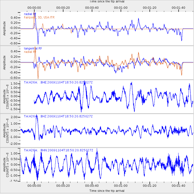
H26A Fairpoint, SD, USA - Earthquake Result Viewer
*The percent match for this event was below the threshold and hence no stack was calculated.
| Earthquake location: |
Azores Islands Region |
| Earthquake latitude/longitude: |
36.2/-33.9 |
| Earthquake time(UTC): |
2009/11/04 (308) 18:41:44 GMT |
| Earthquake Depth: |
10 km |
| Earthquake Magnitude: |
5.7 MB, 5.6 MS, 5.9 MW, 5.8 MW |
| Earthquake Catalog/Contributor: |
WHDF/NEIC |
|
| Network: |
TA USArray Transportable Network (new EarthScope stations) |
| Station: |
H26A Fairpoint, SD, USA |
| Lat/Lon: |
44.62 N/102.77 W |
| Elevation: |
879 m |
|
| Distance: |
51.7 deg |
| Az: |
301.946 deg |
| Baz: |
74.067 deg |
| Ray Param: |
$rayparam |
*The percent match for this event was below the threshold and hence was not used in the summary stack. |
|
| Radial Match: |
57.444572 % |
| Radial Bump: |
400 |
| Transverse Match: |
56.410534 % |
| Transverse Bump: |
400 |
| SOD ConfigId: |
2622 |
| Insert Time: |
2010-03-06 02:35:41.464 +0000 |
| GWidth: |
2.5 |
| Max Bumps: |
400 |
| Tol: |
0.001 |
|
Signal To Noise
| Channel | StoN | STA | LTA |
| TA:H26A: :BHZ:20091104T18:50:20.825027Z | 5.5254154 | 1.1593141E-6 | 2.0981484E-7 |
| TA:H26A: :BHN:20091104T18:50:20.825027Z | 1.6274263 | 6.78325E-7 | 4.1680843E-7 |
| TA:H26A: :BHE:20091104T18:50:20.825027Z | 2.3914444 | 9.1487465E-7 | 3.8256152E-7 |
| Arrivals |
| Ps | |
| PpPs | |
| PsPs/PpSs | |


