You are here: Home > Network List > TA - USArray Transportable Network (new EarthScope stations) Stations List
> Station G27A Dupree, SD, USA > Earthquake Result Viewer
G27A Dupree, SD, USA - Earthquake Result Viewer
| Earthquake location: |
Norwegian Sea |
| Earthquake latitude/longitude: |
72.2/0.9 |
| Earthquake time(UTC): |
2009/08/20 (232) 06:35:04 GMT |
| Earthquake Depth: |
6.0 km |
| Earthquake Magnitude: |
5.9 MB, 5.7 MS, 6.0 MW, 6.0 MW |
| Earthquake Catalog/Contributor: |
WHDF/NEIC |
|
| Network: |
TA USArray Transportable Network (new EarthScope stations) |
| Station: |
G27A Dupree, SD, USA |
| Lat/Lon: |
45.38 N/102.93 W |
| Elevation: |
761 m |
|
| Distance: |
51.5 deg |
| Az: |
298.983 deg |
| Baz: |
22.441 deg |
| Ray Param: |
0.06740949 |
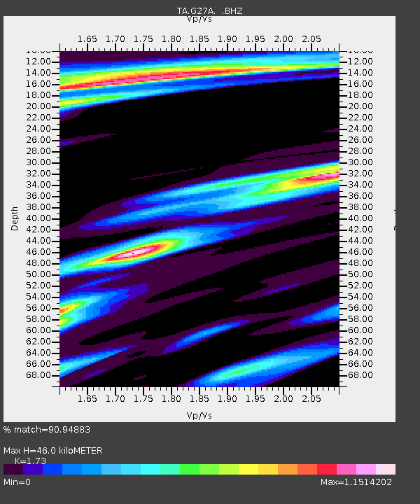
| Estimated Moho Depth: |
46.0 km |
| Estimated Crust Vp/Vs: |
1.73 |
| Assumed Crust Vp: |
6.242 km/s |
| Estimated Crust Vs: |
3.608 km/s |
| Estimated Crust Poisson's Ratio: |
0.25 |
|
| Radial Match: |
90.94883 % |
| Radial Bump: |
329 |
| Transverse Match: |
57.26715 % |
| Transverse Bump: |
400 |
| SOD ConfigId: |
2622 |
| Insert Time: |
2010-03-06 02:35:43.975 +0000 |
| GWidth: |
2.5 |
| Max Bumps: |
400 |
| Tol: |
0.001 |
|

Signal To Noise
| Channel | StoN | STA | LTA |
| TA:G27A: :BHZ:20090820T06:43:37.424019Z | 22.91552 | 1.6507946E-6 | 7.203828E-8 |
| TA:G27A: :BHN:20090820T06:43:37.424019Z | 4.3148613 | 9.055339E-7 | 2.0986398E-7 |
| TA:G27A: :BHE:20090820T06:43:37.424019Z | 0.9330773 | 2.6411865E-7 | 2.8306192E-7 |
| Arrivals |
| Ps | 5.7 SECOND |
| PpPs | 19 SECOND |
| PsPs/PpSs | 25 SECOND |


