You are here: Home > Network List > TA - USArray Transportable Network (new EarthScope stations) Stations List
> Station G27A Dupree, SD, USA > Earthquake Result Viewer
G27A Dupree, SD, USA - Earthquake Result Viewer
| Earthquake location: |
Baffin Bay |
| Earthquake latitude/longitude: |
75.4/-72.5 |
| Earthquake time(UTC): |
2009/07/07 (188) 19:11:46 GMT |
| Earthquake Depth: |
19 km |
| Earthquake Magnitude: |
5.9 MB, 5.7 MS, 6.1 MW, 6.0 MW |
| Earthquake Catalog/Contributor: |
WHDF/NEIC |
|
| Network: |
TA USArray Transportable Network (new EarthScope stations) |
| Station: |
G27A Dupree, SD, USA |
| Lat/Lon: |
45.38 N/102.93 W |
| Elevation: |
761 m |
|
| Distance: |
32.8 deg |
| Az: |
221.302 deg |
| Baz: |
13.788 deg |
| Ray Param: |
0.078483 |
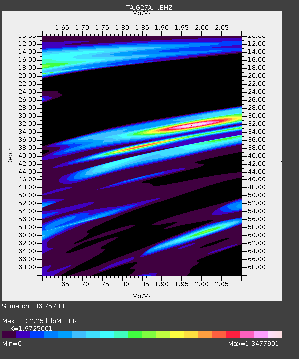
| Estimated Moho Depth: |
32.25 km |
| Estimated Crust Vp/Vs: |
1.97 |
| Assumed Crust Vp: |
6.242 km/s |
| Estimated Crust Vs: |
3.165 km/s |
| Estimated Crust Poisson's Ratio: |
0.33 |
|
| Radial Match: |
86.75733 % |
| Radial Bump: |
286 |
| Transverse Match: |
76.284676 % |
| Transverse Bump: |
400 |
| SOD ConfigId: |
2648 |
| Insert Time: |
2010-03-06 02:35:44.785 +0000 |
| GWidth: |
2.5 |
| Max Bumps: |
400 |
| Tol: |
0.001 |
|

Signal To Noise
| Channel | StoN | STA | LTA |
| TA:G27A: :BHZ:20090707T19:17:48.025002Z | 11.937803 | 1.8665872E-6 | 1.5635935E-7 |
| TA:G27A: :BHN:20090707T19:17:48.025002Z | 6.187468 | 1.7386278E-6 | 2.809918E-7 |
| TA:G27A: :BHE:20090707T19:17:48.025002Z | 1.214621 | 3.0854142E-7 | 2.540228E-7 |
| Arrivals |
| Ps | 5.4 SECOND |
| PpPs | 14 SECOND |
| PsPs/PpSs | 20 SECOND |


