You are here: Home > Network List > TA - USArray Transportable Network (new EarthScope stations) Stations List
> Station F26K Sheenjek River, AK, USA > Earthquake Result Viewer
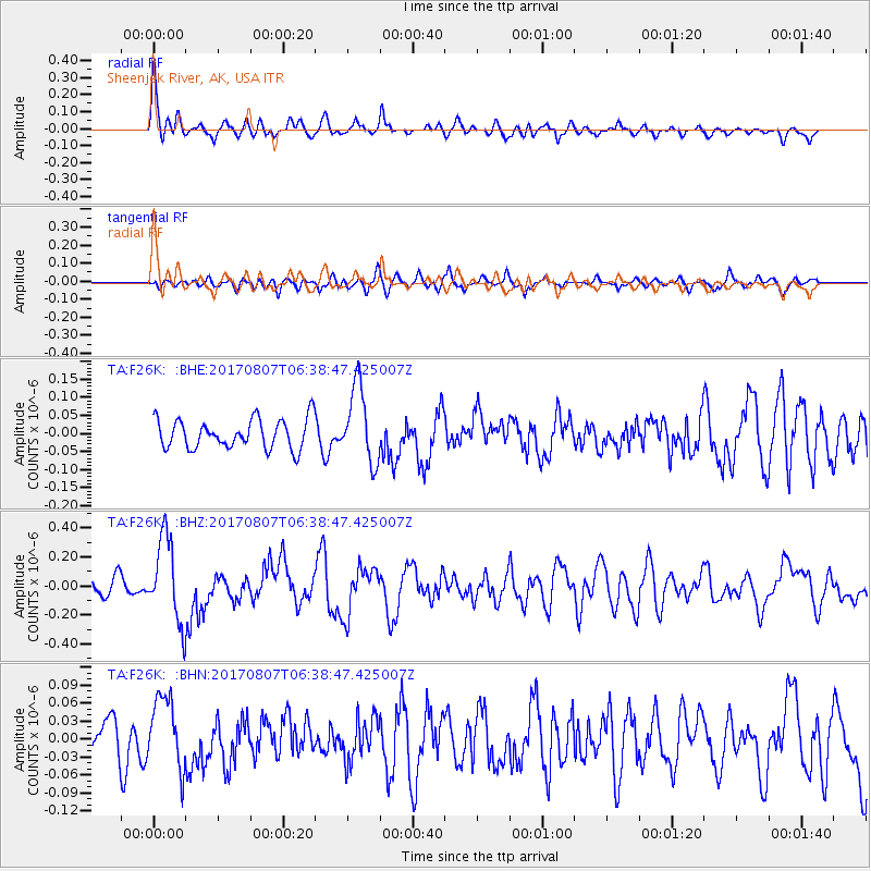
F26K Sheenjek River, AK, USA - Earthquake Result Viewer
*The percent match for this event was below the threshold and hence no stack was calculated.
| Earthquake location: |
New Britain Region, P.N.G. |
| Earthquake latitude/longitude: |
-5.4/151.6 |
| Earthquake time(UTC): |
2017/08/07 (219) 06:26:44 GMT |
| Earthquake Depth: |
35 km |
| Earthquake Magnitude: |
5.8 Mww |
| Earthquake Catalog/Contributor: |
NEIC PDE/us |
|
| Network: |
TA USArray Transportable Network (new EarthScope stations) |
| Station: |
F26K Sheenjek River, AK, USA |
| Lat/Lon: |
67.69 N/144.15 W |
| Elevation: |
683 m |
|
| Distance: |
85.5 deg |
| Az: |
20.183 deg |
| Baz: |
244.143 deg |
| Ray Param: |
$rayparam |
*The percent match for this event was below the threshold and hence was not used in the summary stack. |
|
| Radial Match: |
70.291145 % |
| Radial Bump: |
400 |
| Transverse Match: |
61.7075 % |
| Transverse Bump: |
400 |
| SOD ConfigId: |
13570011 |
| Insert Time: |
2019-04-28 13:10:57.907 +0000 |
| GWidth: |
2.5 |
| Max Bumps: |
400 |
| Tol: |
0.001 |
|
Signal To Noise
| Channel | StoN | STA | LTA |
| TA:F26K: :BHZ:20170807T06:38:47.425007Z | 5.4962716 | 2.9220573E-7 | 5.3164356E-8 |
| TA:F26K: :BHN:20170807T06:38:47.425007Z | 1.6366609 | 6.003416E-8 | 3.668088E-8 |
| TA:F26K: :BHE:20170807T06:38:47.425007Z | 2.6142716 | 1.05628835E-7 | 4.040469E-8 |
| Arrivals |
| Ps | |
| PpPs | |
| PsPs/PpSs | |


