You are here: Home > Network List > US - United States National Seismic Network Stations List
> Station EGMT Eagleton, Montana, USA > Earthquake Result Viewer
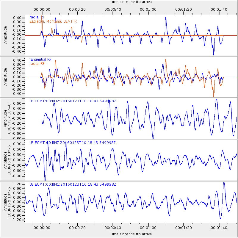
EGMT Eagleton, Montana, USA - Earthquake Result Viewer
*The percent match for this event was below the threshold and hence no stack was calculated.
| Earthquake location: |
Easter Island Region |
| Earthquake latitude/longitude: |
-22.4/-114.0 |
| Earthquake time(UTC): |
2016/01/23 (023) 10:08:01 GMT |
| Earthquake Depth: |
10 km |
| Earthquake Magnitude: |
5.5 MB |
| Earthquake Catalog/Contributor: |
NEIC PDE/NEIC COMCAT |
|
| Network: |
US United States National Seismic Network |
| Station: |
EGMT Eagleton, Montana, USA |
| Lat/Lon: |
48.02 N/109.75 W |
| Elevation: |
1055 m |
|
| Distance: |
70.2 deg |
| Az: |
3.004 deg |
| Baz: |
184.144 deg |
| Ray Param: |
$rayparam |
*The percent match for this event was below the threshold and hence was not used in the summary stack. |
|
| Radial Match: |
50.16644 % |
| Radial Bump: |
262 |
| Transverse Match: |
50.62038 % |
| Transverse Bump: |
370 |
| SOD ConfigId: |
1399611 |
| Insert Time: |
2016-02-06 10:31:29.595 +0000 |
| GWidth: |
2.5 |
| Max Bumps: |
400 |
| Tol: |
0.001 |
|
Signal To Noise
| Channel | StoN | STA | LTA |
| US:EGMT:00:BHZ:20160123T10:18:43.549998Z | 3.228989 | 5.748096E-7 | 1.7801536E-7 |
| US:EGMT:00:BH1:20160123T10:18:43.549998Z | 1.4890641 | 6.067247E-7 | 4.074537E-7 |
| US:EGMT:00:BH2:20160123T10:18:43.549998Z | 0.83167446 | 1.9032802E-7 | 2.2884919E-7 |
| Arrivals |
| Ps | |
| PpPs | |
| PsPs/PpSs | |


