You are here: Home > Network List > TA - USArray Transportable Network (new EarthScope stations) Stations List
> Station J25K Salcha River, AK, USA > Earthquake Result Viewer
J25K Salcha River, AK, USA - Earthquake Result Viewer
| Earthquake location: |
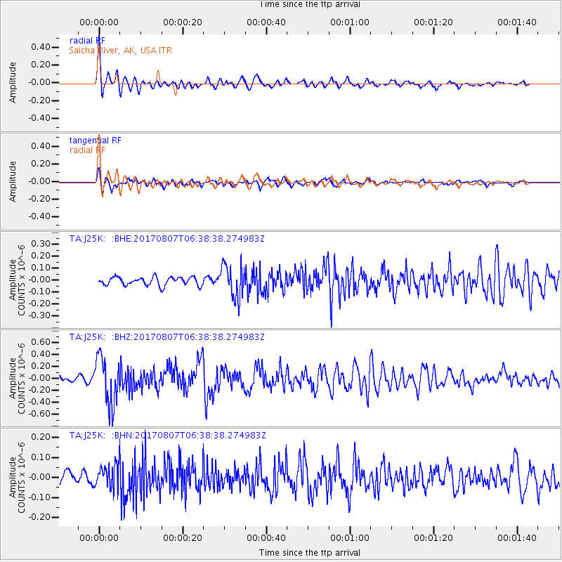
New Britain Region, P.N.G. |
| Earthquake latitude/longitude: |
-5.4/151.6 |
| Earthquake time(UTC): |
2017/08/07 (219) 06:26:44 GMT |
| Earthquake Depth: |
35 km |
| Earthquake Magnitude: |
5.8 Mww |
| Earthquake Catalog/Contributor: |
NEIC PDE/us |
|
| Network: |
TA USArray Transportable Network (new EarthScope stations) |
| Station: |
J25K Salcha River, AK, USA |
| Lat/Lon: |
64.61 N/145.37 W |
| Elevation: |
949 m |
|
| Distance: |
83.7 deg |
| Az: |
22.749 deg |
| Baz: |
243.266 deg |
| Ray Param: |
0.045965172 |
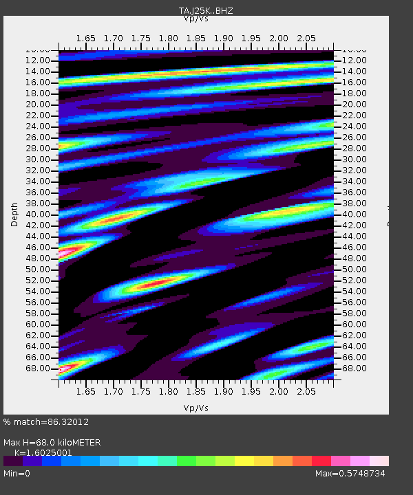
| Estimated Moho Depth: |
68.0 km |
| Estimated Crust Vp/Vs: |
1.60 |
| Assumed Crust Vp: |
6.566 km/s |
| Estimated Crust Vs: |
4.097 km/s |
| Estimated Crust Poisson's Ratio: |
0.18 |
|
| Radial Match: |
86.32012 % |
| Radial Bump: |
400 |
| Transverse Match: |
67.75942 % |
| Transverse Bump: |
400 |
| SOD ConfigId: |
13570011 |
| Insert Time: |
2019-04-28 13:11:28.745 +0000 |
| GWidth: |
2.5 |
| Max Bumps: |
400 |
| Tol: |
0.001 |
|
Signal To Noise
| Channel | StoN | STA | LTA |
| TA:J25K: :BHZ:20170807T06:38:38.274983Z | 9.834269 | 4.0081542E-7 | 4.0757016E-8 |
| TA:J25K: :BHN:20170807T06:38:38.274983Z | 1.8238051 | 5.6370567E-8 | 3.0908218E-8 |
| TA:J25K: :BHE:20170807T06:38:38.274983Z | 4.040149 | 1.3770325E-7 | 3.4083705E-8 |
| Arrivals |
| Ps | 6.4 SECOND |
| PpPs | 26 SECOND |
| PsPs/PpSs | 33 SECOND |


