You are here: Home > Network List > TA - USArray Transportable Network (new EarthScope stations) Stations List
> Station O17K Koliganek, Bristol Bay, AK, USA > Earthquake Result Viewer
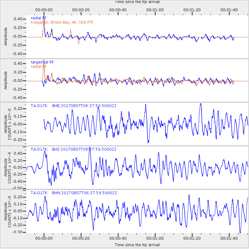
O17K Koliganek, Bristol Bay, AK, USA - Earthquake Result Viewer
*The percent match for this event was below the threshold and hence no stack was calculated.
| Earthquake location: |
New Britain Region, P.N.G. |
| Earthquake latitude/longitude: |
-5.4/151.6 |
| Earthquake time(UTC): |
2017/08/07 (219) 06:26:44 GMT |
| Earthquake Depth: |
35 km |
| Earthquake Magnitude: |
5.8 Mww |
| Earthquake Catalog/Contributor: |
NEIC PDE/us |
|
| Network: |
TA USArray Transportable Network (new EarthScope stations) |
| Station: |
O17K Koliganek, Bristol Bay, AK, USA |
| Lat/Lon: |
59.77 N/157.09 W |
| Elevation: |
156 m |
|
| Distance: |
76.5 deg |
| Az: |
23.979 deg |
| Baz: |
233.105 deg |
| Ray Param: |
$rayparam |
*The percent match for this event was below the threshold and hence was not used in the summary stack. |
|
| Radial Match: |
78.621185 % |
| Radial Bump: |
366 |
| Transverse Match: |
58.653893 % |
| Transverse Bump: |
360 |
| SOD ConfigId: |
13570011 |
| Insert Time: |
2019-04-28 13:12:05.156 +0000 |
| GWidth: |
2.5 |
| Max Bumps: |
400 |
| Tol: |
0.001 |
|
Signal To Noise
| Channel | StoN | STA | LTA |
| TA:O17K: :BHZ:20170807T06:37:59.50002Z | 4.7704396 | 3.1665485E-7 | 6.637855E-8 |
| TA:O17K: :BHN:20170807T06:37:59.50002Z | 1.853207 | 1.09160474E-7 | 5.8903552E-8 |
| TA:O17K: :BHE:20170807T06:37:59.50002Z | 1.5986792 | 1.14195224E-7 | 7.143098E-8 |
| Arrivals |
| Ps | |
| PpPs | |
| PsPs/PpSs | |


