You are here: Home > Network List > TA - USArray Transportable Network (new EarthScope stations) Stations List
> Station H19A Powell, WY, USA > Earthquake Result Viewer
H19A Powell, WY, USA - Earthquake Result Viewer
| Earthquake location: |
Tonga Islands |
| Earthquake latitude/longitude: |
-21.9/-173.8 |
| Earthquake time(UTC): |
2008/10/19 (293) 05:10:33 GMT |
| Earthquake Depth: |
29 km |
| Earthquake Magnitude: |
6.8 MB, 7.0 MS, 6.9 MW, 6.9 MW |
| Earthquake Catalog/Contributor: |
WHDF/NEIC |
|
| Network: |
TA USArray Transportable Network (new EarthScope stations) |
| Station: |
H19A Powell, WY, USA |
| Lat/Lon: |
44.67 N/108.99 W |
| Elevation: |
1479 m |
|
| Distance: |
88.7 deg |
| Az: |
40.237 deg |
| Baz: |
237.243 deg |
| Ray Param: |
0.04234703 |
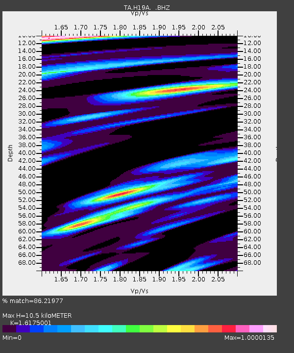
| Estimated Moho Depth: |
10.5 km |
| Estimated Crust Vp/Vs: |
1.62 |
| Assumed Crust Vp: |
6.242 km/s |
| Estimated Crust Vs: |
3.859 km/s |
| Estimated Crust Poisson's Ratio: |
0.19 |
|
| Radial Match: |
86.21977 % |
| Radial Bump: |
305 |
| Transverse Match: |
86.17873 % |
| Transverse Bump: |
383 |
| SOD ConfigId: |
2556 |
| Insert Time: |
2010-03-06 02:36:27.060 +0000 |
| GWidth: |
2.5 |
| Max Bumps: |
400 |
| Tol: |
0.001 |
|

Signal To Noise
| Channel | StoN | STA | LTA |
| TA:H19A: :BHZ:20081019T05:22:53.250027Z | 21.494753 | 5.9619783E-6 | 2.7736903E-7 |
| TA:H19A: :BHN:20081019T05:22:53.250027Z | 2.8936784 | 9.71344E-7 | 3.3567792E-7 |
| TA:H19A: :BHE:20081019T05:22:53.250027Z | 2.5408552 | 1.1787964E-6 | 4.6393686E-7 |
| Arrivals |
| Ps | 1.1 SECOND |
| PpPs | 4.3 SECOND |
| PsPs/PpSs | 5.4 SECOND |


