You are here: Home > Network List > AG - Arkansas Seismic Network Stations List
> Station CCAR Cane Creek, AR > Earthquake Result Viewer
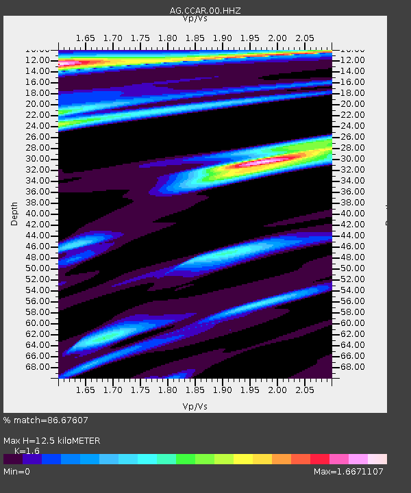
CCAR Cane Creek, AR - Earthquake Result Viewer
| Earthquake location: |
Southern Alaska |
| Earthquake latitude/longitude: |
59.7/-153.5 |
| Earthquake time(UTC): |
2016/01/24 (024) 10:30:30 GMT |
| Earthquake Depth: |
128 km |
| Earthquake Magnitude: |
7.1 MWW, 6.4 ML |
| Earthquake Catalog/Contributor: |
NEIC PDE/NEIC COMCAT |
|
| Network: |
AG Arkansas Seismic Network |
| Station: |
CCAR Cane Creek, AR |
| Lat/Lon: |
33.92 N/91.77 W |
| Elevation: |
72 m |
|
| Distance: |
47.3 deg |
| Az: |
94.522 deg |
| Baz: |
322.511 deg |
| Ray Param: |
0.06967139 |
| Estimated Moho Depth: |
12.5 km |
| Estimated Crust Vp/Vs: |
1.60 |
| Assumed Crust Vp: |
6.201 km/s |
| Estimated Crust Vs: |
3.876 km/s |
| Estimated Crust Poisson's Ratio: |
0.18 |
|
| Radial Match: |
86.67607 % |
| Radial Bump: |
318 |
| Transverse Match: |
82.427284 % |
| Transverse Bump: |
392 |
| SOD ConfigId: |
1399611 |
| Insert Time: |
2016-02-07 11:01:40.808 +0000 |
| GWidth: |
2.5 |
| Max Bumps: |
400 |
| Tol: |
0.001 |
|

Signal To Noise
| Channel | StoN | STA | LTA |
| AG:CCAR:00:HHZ:20160124T10:38:19.804985Z | 2.4128392 | 3.151181E-6 | 1.3060054E-6 |
| AG:CCAR:00:HHN:20160124T10:38:19.804985Z | 0.9791535 | 2.0402993E-6 | 2.0837379E-6 |
| AG:CCAR:00:HHE:20160124T10:38:19.804985Z | 0.99071026 | 2.7684407E-6 | 2.7943997E-6 |
| Arrivals |
| Ps | 1.3 SECOND |
| PpPs | 4.9 SECOND |
| PsPs/PpSs | 6.2 SECOND |


