You are here: Home > Network List > TA - USArray Transportable Network (new EarthScope stations) Stations List
> Station H19A Powell, WY, USA > Earthquake Result Viewer
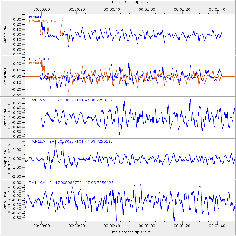
H19A Powell, WY, USA - Earthquake Result Viewer
*The percent match for this event was below the threshold and hence no stack was calculated.
| Earthquake location: |
Lake Baykal Region, Russia |
| Earthquake latitude/longitude: |
51.6/104.2 |
| Earthquake time(UTC): |
2008/08/27 (240) 01:35:32 GMT |
| Earthquake Depth: |
16 km |
| Earthquake Magnitude: |
5.8 MB, 6.2 MS, 6.2 MW, 6.2 MW |
| Earthquake Catalog/Contributor: |
WHDF/NEIC |
|
| Network: |
TA USArray Transportable Network (new EarthScope stations) |
| Station: |
H19A Powell, WY, USA |
| Lat/Lon: |
44.67 N/108.99 W |
| Elevation: |
1479 m |
|
| Distance: |
79.9 deg |
| Az: |
23.343 deg |
| Baz: |
339.738 deg |
| Ray Param: |
$rayparam |
*The percent match for this event was below the threshold and hence was not used in the summary stack. |
|
| Radial Match: |
52.907997 % |
| Radial Bump: |
400 |
| Transverse Match: |
53.03772 % |
| Transverse Bump: |
400 |
| SOD ConfigId: |
2504 |
| Insert Time: |
2010-03-06 02:37:10.984 +0000 |
| GWidth: |
2.5 |
| Max Bumps: |
400 |
| Tol: |
0.001 |
|
Signal To Noise
| Channel | StoN | STA | LTA |
| TA:H19A: :BHZ:20080827T01:47:08.725012Z | 4.2336106 | 5.256407E-7 | 1.2415897E-7 |
| TA:H19A: :BHN:20080827T01:47:08.725012Z | 1.2990947 | 2.2910704E-7 | 1.7635901E-7 |
| TA:H19A: :BHE:20080827T01:47:08.725012Z | 1.2753398 | 2.1956355E-7 | 1.7216081E-7 |
| Arrivals |
| Ps | |
| PpPs | |
| PsPs/PpSs | |


