You are here: Home > Network List > TA - USArray Transportable Network (new EarthScope stations) Stations List
> Station H19A Powell, WY, USA > Earthquake Result Viewer
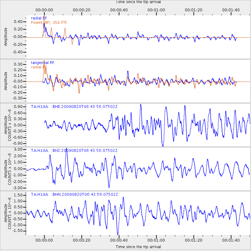
H19A Powell, WY, USA - Earthquake Result Viewer
*The percent match for this event was below the threshold and hence no stack was calculated.
| Earthquake location: |
Norwegian Sea |
| Earthquake latitude/longitude: |
72.2/0.9 |
| Earthquake time(UTC): |
2009/08/20 (232) 06:35:04 GMT |
| Earthquake Depth: |
6.0 km |
| Earthquake Magnitude: |
5.9 MB, 5.7 MS, 6.0 MW, 6.0 MW |
| Earthquake Catalog/Contributor: |
WHDF/NEIC |
|
| Network: |
TA USArray Transportable Network (new EarthScope stations) |
| Station: |
H19A Powell, WY, USA |
| Lat/Lon: |
44.67 N/108.99 W |
| Elevation: |
1479 m |
|
| Distance: |
53.7 deg |
| Az: |
303.674 deg |
| Baz: |
21.022 deg |
| Ray Param: |
$rayparam |
*The percent match for this event was below the threshold and hence was not used in the summary stack. |
|
| Radial Match: |
71.08525 % |
| Radial Bump: |
400 |
| Transverse Match: |
70.45073 % |
| Transverse Bump: |
400 |
| SOD ConfigId: |
2622 |
| Insert Time: |
2010-03-06 02:37:24.156 +0000 |
| GWidth: |
2.5 |
| Max Bumps: |
400 |
| Tol: |
0.001 |
|
Signal To Noise
| Channel | StoN | STA | LTA |
| TA:H19A: :BHZ:20090820T06:43:56.07502Z | 8.685153 | 9.3907437E-7 | 1.081241E-7 |
| TA:H19A: :BHN:20090820T06:43:56.07502Z | 3.2045965 | 3.345566E-7 | 1.0439898E-7 |
| TA:H19A: :BHE:20090820T06:43:56.07502Z | 1.2950324 | 1.5094115E-7 | 1.1655396E-7 |
| Arrivals |
| Ps | |
| PpPs | |
| PsPs/PpSs | |


