You are here: Home > Network List > AK - Alaska Regional Network Stations List
> Station SSN Susitna > Earthquake Result Viewer
SSN Susitna - Earthquake Result Viewer
| Earthquake location: |
Gansu, China |
| Earthquake latitude/longitude: |
33.2/103.8 |
| Earthquake time(UTC): |
2017/08/08 (220) 13:19:49 GMT |
| Earthquake Depth: |
10 km |
| Earthquake Magnitude: |
6.5 Mww |
| Earthquake Catalog/Contributor: |
NEIC PDE/us |
|
| Network: |
AK Alaska Regional Network |
| Station: |
SSN Susitna |
| Lat/Lon: |
61.46 N/150.74 W |
| Elevation: |
1293 m |
|
| Distance: |
68.2 deg |
| Az: |
29.905 deg |
| Baz: |
299.501 deg |
| Ray Param: |
0.05645618 |
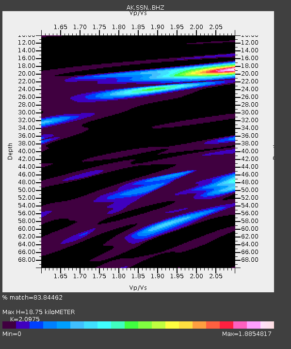
| Estimated Moho Depth: |
18.75 km |
| Estimated Crust Vp/Vs: |
2.10 |
| Assumed Crust Vp: |
6.302 km/s |
| Estimated Crust Vs: |
3.004 km/s |
| Estimated Crust Poisson's Ratio: |
0.35 |
|
| Radial Match: |
83.84462 % |
| Radial Bump: |
400 |
| Transverse Match: |
77.57442 % |
| Transverse Bump: |
400 |
| SOD ConfigId: |
13570011 |
| Insert Time: |
2019-04-28 13:22:23.741 +0000 |
| GWidth: |
2.5 |
| Max Bumps: |
400 |
| Tol: |
0.001 |
|

Signal To Noise
| Channel | StoN | STA | LTA |
| AK:SSN: :BHZ:20170808T13:30:19.127983Z | 6.811986 | 6.806817E-7 | 9.9924115E-8 |
| AK:SSN: :BHN:20170808T13:30:19.127983Z | 1.4957579 | 1.384361E-7 | 9.255249E-8 |
| AK:SSN: :BHE:20170808T13:30:19.127983Z | 2.8663168 | 3.6828135E-7 | 1.2848592E-7 |
| Arrivals |
| Ps | 3.4 SECOND |
| PpPs | 8.9 SECOND |
| PsPs/PpSs | 12 SECOND |


