You are here: Home > Network List > AV - Alaska Volcano Observatory Stations List
> Station MAPS Pakushin Southeast, Makushin Volcano, Alaska > Earthquake Result Viewer
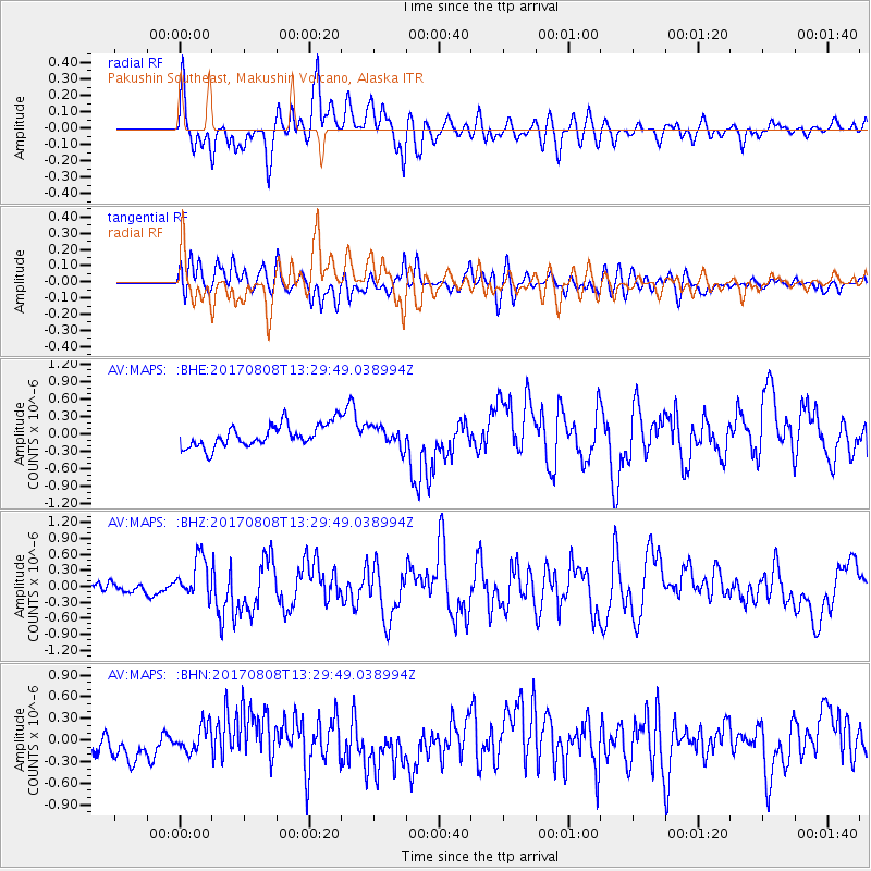
MAPS Pakushin Southeast, Makushin Volcano, Alaska - Earthquake Result Viewer
*The percent match for this event was below the threshold and hence no stack was calculated.
| Earthquake location: |
Gansu, China |
| Earthquake latitude/longitude: |
33.2/103.8 |
| Earthquake time(UTC): |
2017/08/08 (220) 13:19:49 GMT |
| Earthquake Depth: |
10 km |
| Earthquake Magnitude: |
6.5 Mww |
| Earthquake Catalog/Contributor: |
NEIC PDE/us |
|
| Network: |
AV Alaska Volcano Observatory |
| Station: |
MAPS Pakushin Southeast, Makushin Volcano, Alaska |
| Lat/Lon: |
53.81 N/166.94 W |
| Elevation: |
333 m |
|
| Distance: |
63.5 deg |
| Az: |
41.49 deg |
| Baz: |
290.544 deg |
| Ray Param: |
$rayparam |
*The percent match for this event was below the threshold and hence was not used in the summary stack. |
|
| Radial Match: |
64.81443 % |
| Radial Bump: |
400 |
| Transverse Match: |
62.117092 % |
| Transverse Bump: |
400 |
| SOD ConfigId: |
13570011 |
| Insert Time: |
2019-04-28 13:23:12.239 +0000 |
| GWidth: |
2.5 |
| Max Bumps: |
400 |
| Tol: |
0.001 |
|
Signal To Noise
| Channel | StoN | STA | LTA |
| AV:MAPS: :BHZ:20170808T13:29:49.038994Z | 3.018285 | 3.8642338E-7 | 1.2802747E-7 |
| AV:MAPS: :BHN:20170808T13:29:49.038994Z | 1.1195151 | 1.836735E-7 | 1.6406524E-7 |
| AV:MAPS: :BHE:20170808T13:29:49.038994Z | 0.89190274 | 1.7286473E-7 | 1.9381567E-7 |
| Arrivals |
| Ps | |
| PpPs | |
| PsPs/PpSs | |


