You are here: Home > Network List > TA - USArray Transportable Network (new EarthScope stations) Stations List
> Station H19A Powell, WY, USA > Earthquake Result Viewer
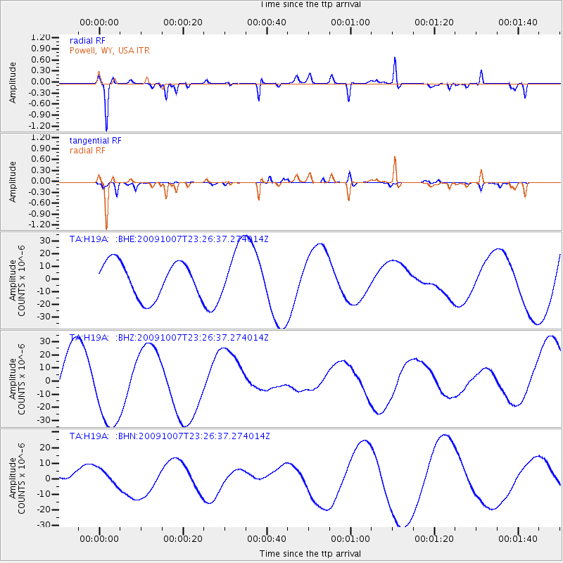
H19A Powell, WY, USA - Earthquake Result Viewer
*The percent match for this event was below the threshold and hence no stack was calculated.
| Earthquake location: |
Vanuatu Islands |
| Earthquake latitude/longitude: |
-13.1/166.5 |
| Earthquake time(UTC): |
2009/10/07 (280) 23:13:48 GMT |
| Earthquake Depth: |
31 km |
| Earthquake Magnitude: |
6.4 MB, 7.2 MS, 7.4 MW, 7.4 MW |
| Earthquake Catalog/Contributor: |
WHDF/NEIC |
|
| Network: |
TA USArray Transportable Network (new EarthScope stations) |
| Station: |
H19A Powell, WY, USA |
| Lat/Lon: |
44.67 N/108.99 W |
| Elevation: |
1479 m |
|
| Distance: |
95.2 deg |
| Az: |
45.499 deg |
| Baz: |
256.892 deg |
| Ray Param: |
$rayparam |
*The percent match for this event was below the threshold and hence was not used in the summary stack. |
|
| Radial Match: |
90.863235 % |
| Radial Bump: |
256 |
| Transverse Match: |
82.56017 % |
| Transverse Bump: |
230 |
| SOD ConfigId: |
2622 |
| Insert Time: |
2010-03-06 02:37:34.363 +0000 |
| GWidth: |
2.5 |
| Max Bumps: |
400 |
| Tol: |
0.001 |
|
Signal To Noise
| Channel | StoN | STA | LTA |
| TA:H19A: :BHZ:20091007T23:26:37.274014Z | 1.4457008 | 2.8922603E-5 | 2.000594E-5 |
| TA:H19A: :BHN:20091007T23:26:37.274014Z | 0.52922744 | 5.2896385E-6 | 9.995019E-6 |
| TA:H19A: :BHE:20091007T23:26:37.274014Z | 1.5570532 | 2.1647897E-5 | 1.3903119E-5 |
| Arrivals |
| Ps | |
| PpPs | |
| PsPs/PpSs | |


