You are here: Home > Network List > GS - US Geological Survey Networks Stations List
> Station KAN08 Pence Farm, Harper, KS, USA > Earthquake Result Viewer
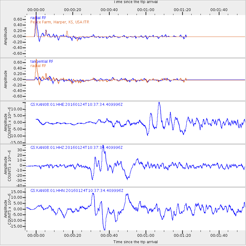
KAN08 Pence Farm, Harper, KS, USA - Earthquake Result Viewer
| Earthquake location: |
Southern Alaska |
| Earthquake latitude/longitude: |
59.7/-153.5 |
| Earthquake time(UTC): |
2016/01/24 (024) 10:30:30 GMT |
| Earthquake Depth: |
128 km |
| Earthquake Magnitude: |
7.1 MWW, 6.4 ML |
| Earthquake Catalog/Contributor: |
NEIC PDE/NEIC COMCAT |
|
| Network: |
GS US Geological Survey Networks |
| Station: |
KAN08 Pence Farm, Harper, KS, USA |
| Lat/Lon: |
37.23 N/97.97 W |
| Elevation: |
375 m |
|
| Distance: |
41.5 deg |
| Az: |
97.268 deg |
| Baz: |
320.882 deg |
| Ray Param: |
0.07326878 |
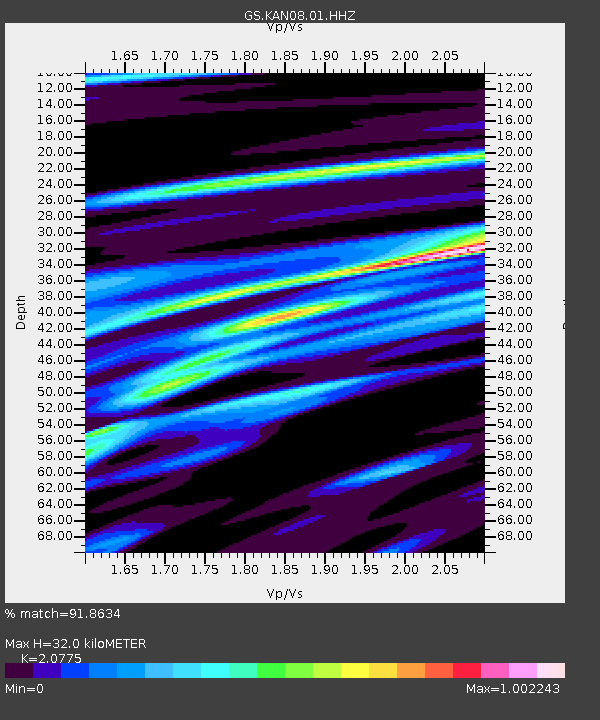
| Estimated Moho Depth: |
32.0 km |
| Estimated Crust Vp/Vs: |
2.08 |
| Assumed Crust Vp: |
6.483 km/s |
| Estimated Crust Vs: |
3.12 km/s |
| Estimated Crust Poisson's Ratio: |
0.35 |
|
| Radial Match: |
91.8634 % |
| Radial Bump: |
300 |
| Transverse Match: |
63.212685 % |
| Transverse Bump: |
354 |
| SOD ConfigId: |
1399611 |
| Insert Time: |
2016-02-07 11:04:30.554 +0000 |
| GWidth: |
2.5 |
| Max Bumps: |
400 |
| Tol: |
0.001 |
|
Signal To Noise
| Channel | StoN | STA | LTA |
| GS:KAN08:01:HHZ:20160124T10:37:34.409996Z | 2.3298316 | 1.4968157E-6 | 6.424566E-7 |
| GS:KAN08:01:HHN:20160124T10:37:34.409996Z | 2.336869 | 2.428936E-6 | 1.0393976E-6 |
| GS:KAN08:01:HHE:20160124T10:37:34.409996Z | 1.2989358 | 1.1632745E-6 | 8.955597E-7 |
| Arrivals |
| Ps | 5.6 SECOND |
| PpPs | 14 SECOND |
| PsPs/PpSs | 20 SECOND |


