You are here: Home > Network List > GS - US Geological Survey Networks Stations List
> Station KAN12 Houston Home, Harper, KS, USA > Earthquake Result Viewer
KAN12 Houston Home, Harper, KS, USA - Earthquake Result Viewer
| Earthquake location: |
Southern Alaska |
| Earthquake latitude/longitude: |
59.7/-153.5 |
| Earthquake time(UTC): |
2016/01/24 (024) 10:30:30 GMT |
| Earthquake Depth: |
128 km |
| Earthquake Magnitude: |
7.1 MWW, 6.4 ML |
| Earthquake Catalog/Contributor: |
NEIC PDE/NEIC COMCAT |
|
| Network: |
GS US Geological Survey Networks |
| Station: |
KAN12 Houston Home, Harper, KS, USA |
| Lat/Lon: |
37.30 N/98.00 W |
| Elevation: |
426 m |
|
| Distance: |
41.5 deg |
| Az: |
97.226 deg |
| Baz: |
320.834 deg |
| Ray Param: |
0.07330771 |
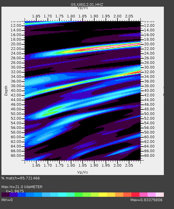
| Estimated Moho Depth: |
21.0 km |
| Estimated Crust Vp/Vs: |
1.97 |
| Assumed Crust Vp: |
6.483 km/s |
| Estimated Crust Vs: |
3.295 km/s |
| Estimated Crust Poisson's Ratio: |
0.33 |
|
| Radial Match: |
95.721466 % |
| Radial Bump: |
309 |
| Transverse Match: |
79.950455 % |
| Transverse Bump: |
400 |
| SOD ConfigId: |
1399611 |
| Insert Time: |
2016-02-07 11:04:37.469 +0000 |
| GWidth: |
2.5 |
| Max Bumps: |
400 |
| Tol: |
0.001 |
|

Signal To Noise
| Channel | StoN | STA | LTA |
| GS:KAN12:01:HHZ:20160124T10:37:33.853997Z | 3.7774522 | 1.7302168E-6 | 4.5803802E-7 |
| GS:KAN12:01:HHN:20160124T10:37:33.853997Z | 1.2812669 | 9.708217E-7 | 7.577045E-7 |
| GS:KAN12:01:HHE:20160124T10:37:33.853997Z | 1.558853 | 1.3377093E-6 | 8.5813684E-7 |
| Arrivals |
| Ps | 3.3 SECOND |
| PpPs | 9.0 SECOND |
| PsPs/PpSs | 12 SECOND |


