You are here: Home > Network List > RV - Regional Alberta Seismic Observatory for Earthquake Studies Network Stations List
> Station HILA High Level, AB > Earthquake Result Viewer
HILA High Level, AB - Earthquake Result Viewer
| Earthquake location: |
Gansu, China |
| Earthquake latitude/longitude: |
33.2/103.8 |
| Earthquake time(UTC): |
2017/08/08 (220) 13:19:49 GMT |
| Earthquake Depth: |
10 km |
| Earthquake Magnitude: |
6.5 Mww |
| Earthquake Catalog/Contributor: |
NEIC PDE/us |
|
| Network: |
RV Regional Alberta Seismic Observatory for Earthquake Studies Network |
| Station: |
HILA High Level, AB |
| Lat/Lon: |
58.56 N/117.02 W |
| Elevation: |
329 m |
|
| Distance: |
82.4 deg |
| Az: |
20.243 deg |
| Baz: |
326.407 deg |
| Ray Param: |
0.046902608 |
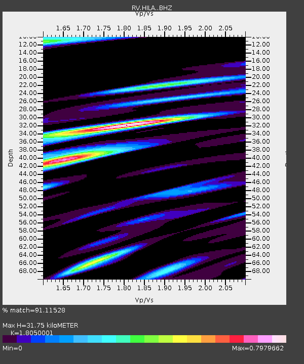
| Estimated Moho Depth: |
31.75 km |
| Estimated Crust Vp/Vs: |
1.81 |
| Assumed Crust Vp: |
6.498 km/s |
| Estimated Crust Vs: |
3.6 km/s |
| Estimated Crust Poisson's Ratio: |
0.28 |
|
| Radial Match: |
91.11528 % |
| Radial Bump: |
400 |
| Transverse Match: |
71.62598 % |
| Transverse Bump: |
400 |
| SOD ConfigId: |
13570011 |
| Insert Time: |
2019-04-28 13:26:38.540 +0000 |
| GWidth: |
2.5 |
| Max Bumps: |
400 |
| Tol: |
0.001 |
|

Signal To Noise
| Channel | StoN | STA | LTA |
| RV:HILA: :BHZ:20170808T13:31:40.624993Z | 11.871673 | 1.3136778E-5 | 1.106565E-6 |
| RV:HILA: :BHN:20170808T13:31:40.624993Z | 1.3160665 | 3.1997486E-6 | 2.431297E-6 |
| RV:HILA: :BHE:20170808T13:31:40.624993Z | 2.2072015 | 3.0163508E-6 | 1.3665951E-6 |
| Arrivals |
| Ps | 4.0 SECOND |
| PpPs | 13 SECOND |
| PsPs/PpSs | 17 SECOND |


