You are here: Home > Network List > GS - US Geological Survey Networks Stations List
> Station OK034 N. Norfolk Rd., Cushing, Oklahoma, USA > Earthquake Result Viewer
OK034 N. Norfolk Rd., Cushing, Oklahoma, USA - Earthquake Result Viewer
| Earthquake location: |
Southern Alaska |
| Earthquake latitude/longitude: |
59.7/-153.5 |
| Earthquake time(UTC): |
2016/01/24 (024) 10:30:30 GMT |
| Earthquake Depth: |
128 km |
| Earthquake Magnitude: |
7.1 MWW, 6.4 ML |
| Earthquake Catalog/Contributor: |
NEIC PDE/NEIC COMCAT |
|
| Network: |
GS US Geological Survey Networks |
| Station: |
OK034 N. Norfolk Rd., Cushing, Oklahoma, USA |
| Lat/Lon: |
36.01 N/96.71 W |
| Elevation: |
254 m |
|
| Distance: |
43.1 deg |
| Az: |
97.225 deg |
| Baz: |
321.597 deg |
| Ray Param: |
0.072290875 |
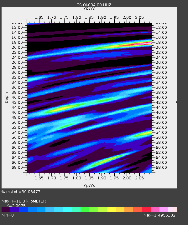
| Estimated Moho Depth: |
18.0 km |
| Estimated Crust Vp/Vs: |
2.10 |
| Assumed Crust Vp: |
6.483 km/s |
| Estimated Crust Vs: |
3.091 km/s |
| Estimated Crust Poisson's Ratio: |
0.35 |
|
| Radial Match: |
80.06477 % |
| Radial Bump: |
400 |
| Transverse Match: |
62.47773 % |
| Transverse Bump: |
400 |
| SOD ConfigId: |
1399611 |
| Insert Time: |
2016-02-07 11:05:01.545 +0000 |
| GWidth: |
2.5 |
| Max Bumps: |
400 |
| Tol: |
0.001 |
|

Signal To Noise
| Channel | StoN | STA | LTA |
| GS:OK034:00:HHZ:20160124T10:37:47.179009Z | 1.5769581 | 1.4571016E-6 | 9.239951E-7 |
| GS:OK034:00:HH1:20160124T10:37:47.179009Z | 1.6839142 | 2.0612022E-6 | 1.2240542E-6 |
| GS:OK034:00:HH2:20160124T10:37:47.179009Z | 1.5955209 | 4.486485E-6 | 2.811925E-6 |
| Arrivals |
| Ps | 3.2 SECOND |
| PpPs | 8.1 SECOND |
| PsPs/PpSs | 11 SECOND |


