You are here: Home > Network List > TA - USArray Transportable Network (new EarthScope stations) Stations List
> Station I17K Unalakleet, AK, USA > Earthquake Result Viewer
I17K Unalakleet, AK, USA - Earthquake Result Viewer
| Earthquake location: |
Gansu, China |
| Earthquake latitude/longitude: |
33.2/103.8 |
| Earthquake time(UTC): |
2017/08/08 (220) 13:19:49 GMT |
| Earthquake Depth: |
10 km |
| Earthquake Magnitude: |
6.5 Mww |
| Earthquake Catalog/Contributor: |
NEIC PDE/us |
|
| Network: |
TA USArray Transportable Network (new EarthScope stations) |
| Station: |
I17K Unalakleet, AK, USA |
| Lat/Lon: |
63.89 N/160.70 W |
| Elevation: |
105 m |
|
| Distance: |
63.0 deg |
| Az: |
29.625 deg |
| Baz: |
290.551 deg |
| Ray Param: |
0.0598457 |
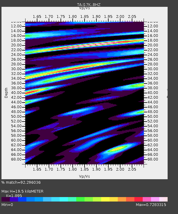
| Estimated Moho Depth: |
19.5 km |
| Estimated Crust Vp/Vs: |
1.89 |
| Assumed Crust Vp: |
6.276 km/s |
| Estimated Crust Vs: |
3.312 km/s |
| Estimated Crust Poisson's Ratio: |
0.31 |
|
| Radial Match: |
92.296036 % |
| Radial Bump: |
400 |
| Transverse Match: |
86.00882 % |
| Transverse Bump: |
400 |
| SOD ConfigId: |
13570011 |
| Insert Time: |
2019-04-28 13:27:38.193 +0000 |
| GWidth: |
2.5 |
| Max Bumps: |
400 |
| Tol: |
0.001 |
|
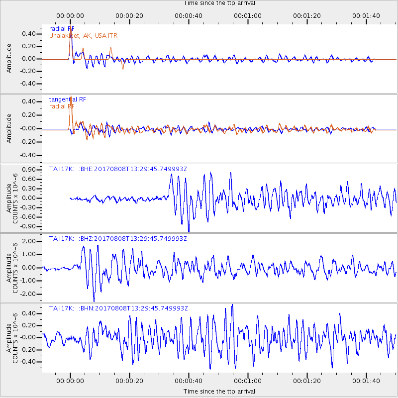
Signal To Noise
| Channel | StoN | STA | LTA |
| TA:I17K: :BHZ:20170808T13:29:45.749993Z | 10.814861 | 6.707568E-7 | 6.202176E-8 |
| TA:I17K: :BHN:20170808T13:29:45.749993Z | 1.5485045 | 7.823259E-8 | 5.0521386E-8 |
| TA:I17K: :BHE:20170808T13:29:45.749993Z | 5.620165 | 2.840308E-7 | 5.0537803E-8 |
| Arrivals |
| Ps | 2.9 SECOND |
| PpPs | 8.7 SECOND |
| PsPs/PpSs | 12 SECOND |


