You are here: Home > Network List > TA - USArray Transportable Network (new EarthScope stations) Stations List
> Station I27K Kandik River, AK, USA > Earthquake Result Viewer
I27K Kandik River, AK, USA - Earthquake Result Viewer
| Earthquake location: |
Gansu, China |
| Earthquake latitude/longitude: |
33.2/103.8 |
| Earthquake time(UTC): |
2017/08/08 (220) 13:19:49 GMT |
| Earthquake Depth: |
10 km |
| Earthquake Magnitude: |
6.5 Mww |
| Earthquake Catalog/Contributor: |
NEIC PDE/us |
|
| Network: |
TA USArray Transportable Network (new EarthScope stations) |
| Station: |
I27K Kandik River, AK, USA |
| Lat/Lon: |
65.60 N/141.62 W |
| Elevation: |
874 m |
|
| Distance: |
69.4 deg |
| Az: |
23.801 deg |
| Baz: |
305.464 deg |
| Ray Param: |
0.05565328 |
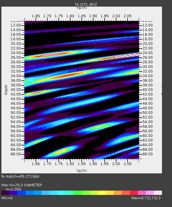
| Estimated Moho Depth: |
25.0 km |
| Estimated Crust Vp/Vs: |
2.06 |
| Assumed Crust Vp: |
6.566 km/s |
| Estimated Crust Vs: |
3.195 km/s |
| Estimated Crust Poisson's Ratio: |
0.34 |
|
| Radial Match: |
95.371864 % |
| Radial Bump: |
400 |
| Transverse Match: |
86.14242 % |
| Transverse Bump: |
400 |
| SOD ConfigId: |
13570011 |
| Insert Time: |
2019-04-28 13:27:42.393 +0000 |
| GWidth: |
2.5 |
| Max Bumps: |
400 |
| Tol: |
0.001 |
|

Signal To Noise
| Channel | StoN | STA | LTA |
| TA:I27K: :BHZ:20170808T13:30:26.749993Z | 7.377873 | 5.6529973E-7 | 7.6620964E-8 |
| TA:I27K: :BHN:20170808T13:30:26.749993Z | 2.7204301 | 1.3123852E-7 | 4.8241827E-8 |
| TA:I27K: :BHE:20170808T13:30:26.749993Z | 9.000227 | 2.0591403E-7 | 2.2878758E-8 |
| Arrivals |
| Ps | 4.2 SECOND |
| PpPs | 11 SECOND |
| PsPs/PpSs | 15 SECOND |


