You are here: Home > Network List > TA - USArray Transportable Network (new EarthScope stations) Stations List
> Station 118A Homack Ranch, Wilcox, AZ, USA > Earthquake Result Viewer
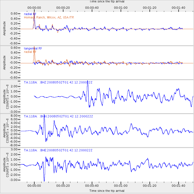
118A Homack Ranch, Wilcox, AZ, USA - Earthquake Result Viewer
| Earthquake location: |
Andreanof Islands, Aleutian Is. |
| Earthquake latitude/longitude: |
51.9/-177.5 |
| Earthquake time(UTC): |
2008/05/02 (123) 01:33:37 GMT |
| Earthquake Depth: |
14 km |
| Earthquake Magnitude: |
6.3 MB, 6.8 MS, 6.6 MW, 6.6 MW |
| Earthquake Catalog/Contributor: |
WHDF/NEIC |
|
| Network: |
TA USArray Transportable Network (new EarthScope stations) |
| Station: |
118A Homack Ranch, Wilcox, AZ, USA |
| Lat/Lon: |
32.64 N/109.97 W |
| Elevation: |
1440 m |
|
| Distance: |
51.6 deg |
| Az: |
84.13 deg |
| Baz: |
313.021 deg |
| Ray Param: |
0.067284115 |
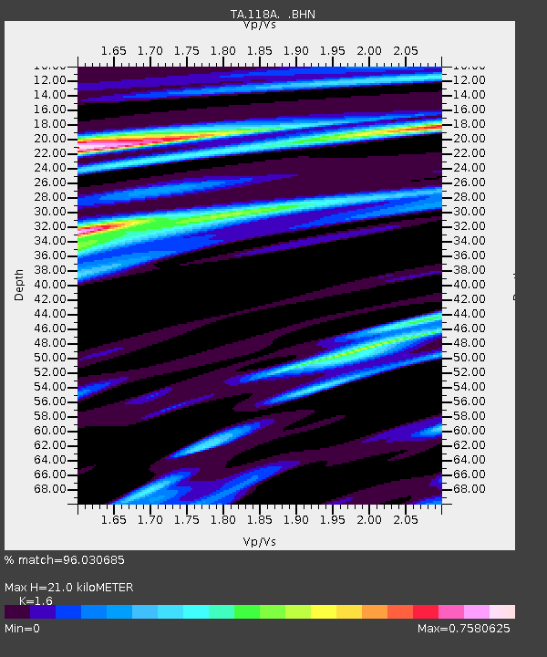
| Estimated Moho Depth: |
21.0 km |
| Estimated Crust Vp/Vs: |
1.60 |
| Assumed Crust Vp: |
6.276 km/s |
| Estimated Crust Vs: |
3.922 km/s |
| Estimated Crust Poisson's Ratio: |
0.18 |
|
| Radial Match: |
96.030685 % |
| Radial Bump: |
322 |
| Transverse Match: |
86.854454 % |
| Transverse Bump: |
400 |
| SOD ConfigId: |
2504 |
| Insert Time: |
2010-03-06 02:38:20.305 +0000 |
| GWidth: |
2.5 |
| Max Bumps: |
400 |
| Tol: |
0.001 |
|
Signal To Noise
| Channel | StoN | STA | LTA |
| TA:118A: :BHN:20080502T01:42:12.200022Z | 16.814505 | 1.2631398E-6 | 7.512203E-8 |
| TA:118A: :BHE:20080502T01:42:12.200022Z | 2.451541 | 3.620712E-7 | 1.4769127E-7 |
| TA:118A: :BHZ:20080502T01:42:12.200022Z | 4.5147676 | 4.1470116E-7 | 9.1854375E-8 |
| Arrivals |
| Ps | 2.1 SECOND |
| PpPs | 8.2 SECOND |
| PsPs/PpSs | 10 SECOND |


