You are here: Home > Network List > TA - USArray Transportable Network (new EarthScope stations) Stations List
> Station 118A Homack Ranch, Wilcox, AZ, USA > Earthquake Result Viewer
118A Homack Ranch, Wilcox, AZ, USA - Earthquake Result Viewer
| Earthquake location: |
Iceland |
| Earthquake latitude/longitude: |
64.0/-21.0 |
| Earthquake time(UTC): |
2008/05/29 (150) 15:46:00 GMT |
| Earthquake Depth: |
10 km |
| Earthquake Magnitude: |
6.0 MB, 6.2 MS, 6.3 MW, 6.2 MW |
| Earthquake Catalog/Contributor: |
WHDF/NEIC |
|
| Network: |
TA USArray Transportable Network (new EarthScope stations) |
| Station: |
118A Homack Ranch, Wilcox, AZ, USA |
| Lat/Lon: |
32.64 N/109.97 W |
| Elevation: |
1440 m |
|
| Distance: |
60.8 deg |
| Az: |
284.794 deg |
| Baz: |
30.332 deg |
| Ray Param: |
0.061326 |
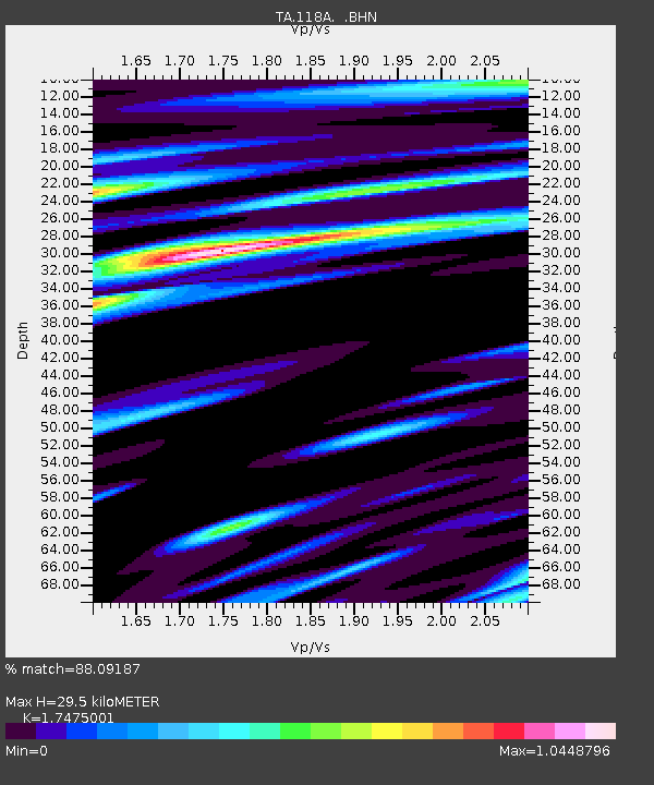
| Estimated Moho Depth: |
29.5 km |
| Estimated Crust Vp/Vs: |
1.75 |
| Assumed Crust Vp: |
6.276 km/s |
| Estimated Crust Vs: |
3.591 km/s |
| Estimated Crust Poisson's Ratio: |
0.26 |
|
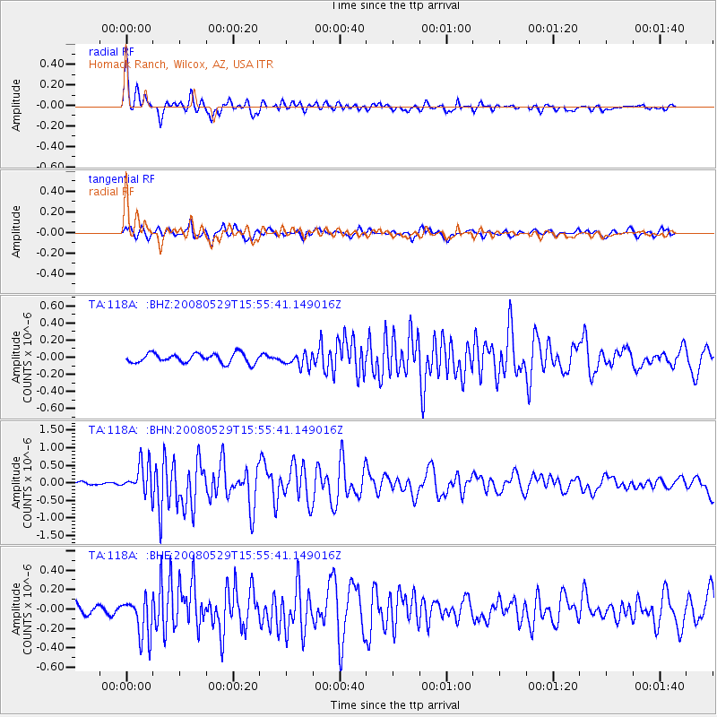
| Radial Match: |
88.09187 % |
| Radial Bump: |
400 |
| Transverse Match: |
68.56151 % |
| Transverse Bump: |
400 |
| SOD ConfigId: |
2504 |
| Insert Time: |
2010-03-06 02:38:21.727 +0000 |
| GWidth: |
2.5 |
| Max Bumps: |
400 |
| Tol: |
0.001 |
|
Signal To Noise
| Channel | StoN | STA | LTA |
| TA:118A: :BHN:20080529T15:55:41.149016Z | 8.411923 | 4.2447292E-7 | 5.0460862E-8 |
| TA:118A: :BHE:20080529T15:55:41.149016Z | 2.2481182 | 2.0756325E-7 | 9.2327554E-8 |
| TA:118A: :BHZ:20080529T15:55:41.149016Z | 1.4483465 | 7.9294715E-8 | 5.4748444E-8 |
| Arrivals |
| Ps | 3.7 SECOND |
| PpPs | 12 SECOND |
| PsPs/PpSs | 16 SECOND |


