You are here: Home > Network List > TA - USArray Transportable Network (new EarthScope stations) Stations List
> Station K27K Chicken, AK, USA > Earthquake Result Viewer
K27K Chicken, AK, USA - Earthquake Result Viewer
| Earthquake location: |
Gansu, China |
| Earthquake latitude/longitude: |
33.2/103.8 |
| Earthquake time(UTC): |
2017/08/08 (220) 13:19:49 GMT |
| Earthquake Depth: |
10 km |
| Earthquake Magnitude: |
6.5 Mww |
| Earthquake Catalog/Contributor: |
NEIC PDE/us |
|
| Network: |
TA USArray Transportable Network (new EarthScope stations) |
| Station: |
K27K Chicken, AK, USA |
| Lat/Lon: |
64.03 N/142.08 W |
| Elevation: |
389 m |
|
| Distance: |
70.2 deg |
| Az: |
25.294 deg |
| Baz: |
305.563 deg |
| Ray Param: |
0.055149198 |
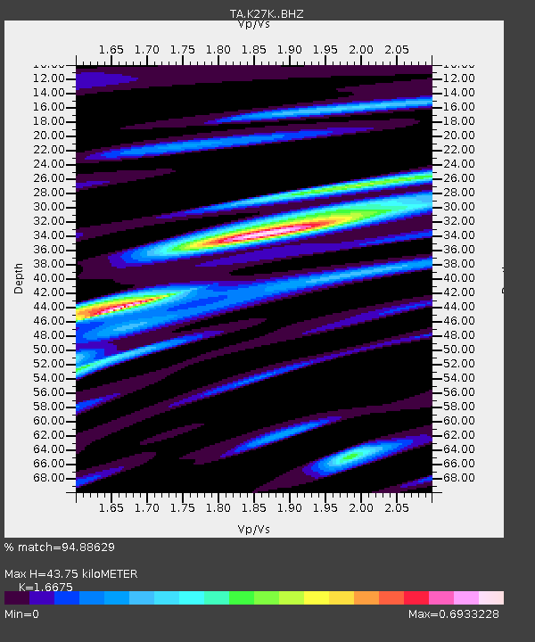
| Estimated Moho Depth: |
43.75 km |
| Estimated Crust Vp/Vs: |
1.67 |
| Assumed Crust Vp: |
6.566 km/s |
| Estimated Crust Vs: |
3.938 km/s |
| Estimated Crust Poisson's Ratio: |
0.22 |
|
| Radial Match: |
94.88629 % |
| Radial Bump: |
373 |
| Transverse Match: |
86.563835 % |
| Transverse Bump: |
400 |
| SOD ConfigId: |
13570011 |
| Insert Time: |
2019-04-28 13:27:57.567 +0000 |
| GWidth: |
2.5 |
| Max Bumps: |
400 |
| Tol: |
0.001 |
|

Signal To Noise
| Channel | StoN | STA | LTA |
| TA:K27K: :BHZ:20170808T13:30:31.400017Z | 12.069105 | 6.171492E-7 | 5.113463E-8 |
| TA:K27K: :BHN:20170808T13:30:31.400017Z | 4.066185 | 1.3780364E-7 | 3.3890156E-8 |
| TA:K27K: :BHE:20170808T13:30:31.400017Z | 5.7836847 | 2.539049E-7 | 4.3900197E-8 |
| Arrivals |
| Ps | 4.6 SECOND |
| PpPs | 17 SECOND |
| PsPs/PpSs | 22 SECOND |


