You are here: Home > Network List > TA - USArray Transportable Network (new EarthScope stations) Stations List
> Station L17K Donlin, AK, USA > Earthquake Result Viewer
L17K Donlin, AK, USA - Earthquake Result Viewer
| Earthquake location: |
Gansu, China |
| Earthquake latitude/longitude: |
33.2/103.8 |
| Earthquake time(UTC): |
2017/08/08 (220) 13:19:49 GMT |
| Earthquake Depth: |
10 km |
| Earthquake Magnitude: |
6.5 Mww |
| Earthquake Catalog/Contributor: |
NEIC PDE/us |
|
| Network: |
TA USArray Transportable Network (new EarthScope stations) |
| Station: |
L17K Donlin, AK, USA |
| Lat/Lon: |
62.13 N/158.30 W |
| Elevation: |
338 m |
|
| Distance: |
64.7 deg |
| Az: |
30.987 deg |
| Baz: |
293.285 deg |
| Ray Param: |
0.05875778 |
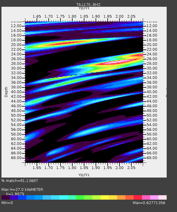
| Estimated Moho Depth: |
27.0 km |
| Estimated Crust Vp/Vs: |
1.99 |
| Assumed Crust Vp: |
6.276 km/s |
| Estimated Crust Vs: |
3.158 km/s |
| Estimated Crust Poisson's Ratio: |
0.33 |
|
| Radial Match: |
91.13687 % |
| Radial Bump: |
360 |
| Transverse Match: |
85.415245 % |
| Transverse Bump: |
400 |
| SOD ConfigId: |
13570011 |
| Insert Time: |
2019-04-28 13:28:00.910 +0000 |
| GWidth: |
2.5 |
| Max Bumps: |
400 |
| Tol: |
0.001 |
|

Signal To Noise
| Channel | StoN | STA | LTA |
| TA:L17K: :BHZ:20170808T13:29:56.725029Z | 8.882465 | 4.8250985E-7 | 5.4321614E-8 |
| TA:L17K: :BHN:20170808T13:29:56.725029Z | 3.190245 | 1.09949156E-7 | 3.4464176E-8 |
| TA:L17K: :BHE:20170808T13:29:56.725029Z | 4.2544694 | 2.1805859E-7 | 5.1254002E-8 |
| Arrivals |
| Ps | 4.4 SECOND |
| PpPs | 12 SECOND |
| PsPs/PpSs | 17 SECOND |


