You are here: Home > Network List > TA - USArray Transportable Network (new EarthScope stations) Stations List
> Station M15K Kasigluk River, AK, USA > Earthquake Result Viewer
M15K Kasigluk River, AK, USA - Earthquake Result Viewer
| Earthquake location: |
Gansu, China |
| Earthquake latitude/longitude: |
33.2/103.8 |
| Earthquake time(UTC): |
2017/08/08 (220) 13:19:49 GMT |
| Earthquake Depth: |
10 km |
| Earthquake Magnitude: |
6.5 Mww |
| Earthquake Catalog/Contributor: |
NEIC PDE/us |
|
| Network: |
TA USArray Transportable Network (new EarthScope stations) |
| Station: |
M15K Kasigluk River, AK, USA |
| Lat/Lon: |
60.69 N/160.69 W |
| Elevation: |
210 m |
|
| Distance: |
64.2 deg |
| Az: |
32.956 deg |
| Baz: |
292.038 deg |
| Ray Param: |
0.05908241 |
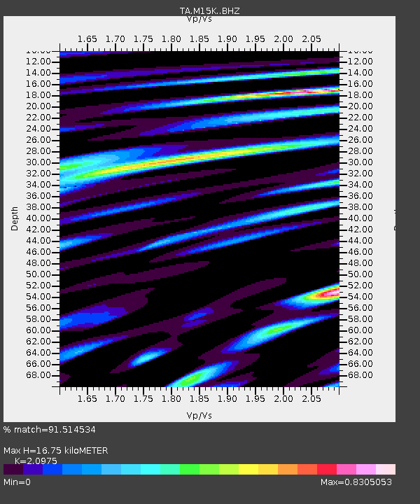
| Estimated Moho Depth: |
16.75 km |
| Estimated Crust Vp/Vs: |
2.10 |
| Assumed Crust Vp: |
6.182 km/s |
| Estimated Crust Vs: |
2.947 km/s |
| Estimated Crust Poisson's Ratio: |
0.35 |
|
| Radial Match: |
91.514534 % |
| Radial Bump: |
400 |
| Transverse Match: |
83.31762 % |
| Transverse Bump: |
400 |
| SOD ConfigId: |
13570011 |
| Insert Time: |
2019-04-28 13:28:07.689 +0000 |
| GWidth: |
2.5 |
| Max Bumps: |
400 |
| Tol: |
0.001 |
|

Signal To Noise
| Channel | StoN | STA | LTA |
| TA:M15K: :BHZ:20170808T13:29:53.42498Z | 13.83485 | 5.8117064E-7 | 4.2007727E-8 |
| TA:M15K: :BHN:20170808T13:29:53.42498Z | 3.1305516 | 1.5988562E-7 | 5.1072664E-8 |
| TA:M15K: :BHE:20170808T13:29:53.42498Z | 6.824299 | 2.7020383E-7 | 3.9594372E-8 |
| Arrivals |
| Ps | 3.1 SECOND |
| PpPs | 8.1 SECOND |
| PsPs/PpSs | 11 SECOND |


