You are here: Home > Network List > II - Global Seismograph Network (GSN - IRIS/IDA) Stations List
> Station LVZ Lovozero, Russia > Earthquake Result Viewer
LVZ Lovozero, Russia - Earthquake Result Viewer
| Earthquake location: |
Southern Alaska |
| Earthquake latitude/longitude: |
59.7/-153.5 |
| Earthquake time(UTC): |
2016/01/24 (024) 10:30:30 GMT |
| Earthquake Depth: |
128 km |
| Earthquake Magnitude: |
7.1 MWW, 6.4 ML |
| Earthquake Catalog/Contributor: |
NEIC PDE/NEIC COMCAT |
|
| Network: |
II Global Seismograph Network (GSN - IRIS/IDA) |
| Station: |
LVZ Lovozero, Russia |
| Lat/Lon: |
67.90 N/34.65 E |
| Elevation: |
630 m |
|
| Distance: |
52.6 deg |
| Az: |
356.15 deg |
| Baz: |
5.168 deg |
| Ray Param: |
0.06622434 |
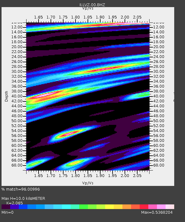
| Estimated Moho Depth: |
10.0 km |
| Estimated Crust Vp/Vs: |
2.07 |
| Assumed Crust Vp: |
6.367 km/s |
| Estimated Crust Vs: |
3.083 km/s |
| Estimated Crust Poisson's Ratio: |
0.35 |
|
| Radial Match: |
96.00996 % |
| Radial Bump: |
341 |
| Transverse Match: |
80.91085 % |
| Transverse Bump: |
400 |
| SOD ConfigId: |
1399611 |
| Insert Time: |
2016-02-07 11:05:44.297 +0000 |
| GWidth: |
2.5 |
| Max Bumps: |
400 |
| Tol: |
0.001 |
|

Signal To Noise
| Channel | StoN | STA | LTA |
| II:LVZ:00:BHZ:20160124T10:39:00.218987Z | 8.554472 | 5.4917546E-6 | 6.4197474E-7 |
| II:LVZ:00:BH1:20160124T10:39:00.218987Z | 6.6354847 | 2.1615106E-6 | 3.2575022E-7 |
| II:LVZ:00:BH2:20160124T10:39:00.218987Z | 0.6277226 | 1.473697E-7 | 2.3476883E-7 |
| Arrivals |
| Ps | 1.8 SECOND |
| PpPs | 4.6 SECOND |
| PsPs/PpSs | 6.4 SECOND |


