You are here: Home > Network List > TA - USArray Transportable Network (new EarthScope stations) Stations List
> Station N14K Kuskokwak Creek, AK, USA > Earthquake Result Viewer
N14K Kuskokwak Creek, AK, USA - Earthquake Result Viewer
| Earthquake location: |
Gansu, China |
| Earthquake latitude/longitude: |
33.2/103.8 |
| Earthquake time(UTC): |
2017/08/08 (220) 13:19:49 GMT |
| Earthquake Depth: |
10 km |
| Earthquake Magnitude: |
6.5 Mww |
| Earthquake Catalog/Contributor: |
NEIC PDE/us |
|
| Network: |
TA USArray Transportable Network (new EarthScope stations) |
| Station: |
N14K Kuskokwak Creek, AK, USA |
| Lat/Lon: |
59.92 N/161.69 W |
| Elevation: |
21 m |
|
| Distance: |
64.0 deg |
| Az: |
33.959 deg |
| Baz: |
291.612 deg |
| Ray Param: |
0.05919723 |
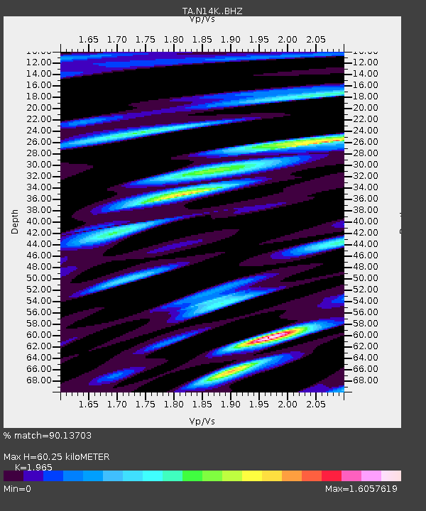
| Estimated Moho Depth: |
60.25 km |
| Estimated Crust Vp/Vs: |
1.97 |
| Assumed Crust Vp: |
6.24 km/s |
| Estimated Crust Vs: |
3.176 km/s |
| Estimated Crust Poisson's Ratio: |
0.33 |
|
| Radial Match: |
90.13703 % |
| Radial Bump: |
400 |
| Transverse Match: |
90.13339 % |
| Transverse Bump: |
400 |
| SOD ConfigId: |
13570011 |
| Insert Time: |
2019-04-28 13:28:19.033 +0000 |
| GWidth: |
2.5 |
| Max Bumps: |
400 |
| Tol: |
0.001 |
|

Signal To Noise
| Channel | StoN | STA | LTA |
| TA:N14K: :BHZ:20170808T13:29:52.29998Z | 9.165905 | 7.0047497E-7 | 7.64218E-8 |
| TA:N14K: :BHN:20170808T13:29:52.29998Z | 1.0398688 | 1.5817855E-7 | 1.5211394E-7 |
| TA:N14K: :BHE:20170808T13:29:52.29998Z | 1.7862928 | 2.4481156E-7 | 1.3705008E-7 |
| Arrivals |
| Ps | 9.7 SECOND |
| PpPs | 28 SECOND |
| PsPs/PpSs | 37 SECOND |


