You are here: Home > Network List > TA - USArray Transportable Network (new EarthScope stations) Stations List
> Station O20K Slope Mountain, AK, USA > Earthquake Result Viewer
O20K Slope Mountain, AK, USA - Earthquake Result Viewer
| Earthquake location: |
Gansu, China |
| Earthquake latitude/longitude: |
33.2/103.8 |
| Earthquake time(UTC): |
2017/08/08 (220) 13:19:49 GMT |
| Earthquake Depth: |
10 km |
| Earthquake Magnitude: |
6.5 Mww |
| Earthquake Catalog/Contributor: |
NEIC PDE/us |
|
| Network: |
TA USArray Transportable Network (new EarthScope stations) |
| Station: |
O20K Slope Mountain, AK, USA |
| Lat/Lon: |
60.08 N/152.62 W |
| Elevation: |
915 m |
|
| Distance: |
68.1 deg |
| Az: |
31.694 deg |
| Baz: |
298.529 deg |
| Ray Param: |
0.056543626 |
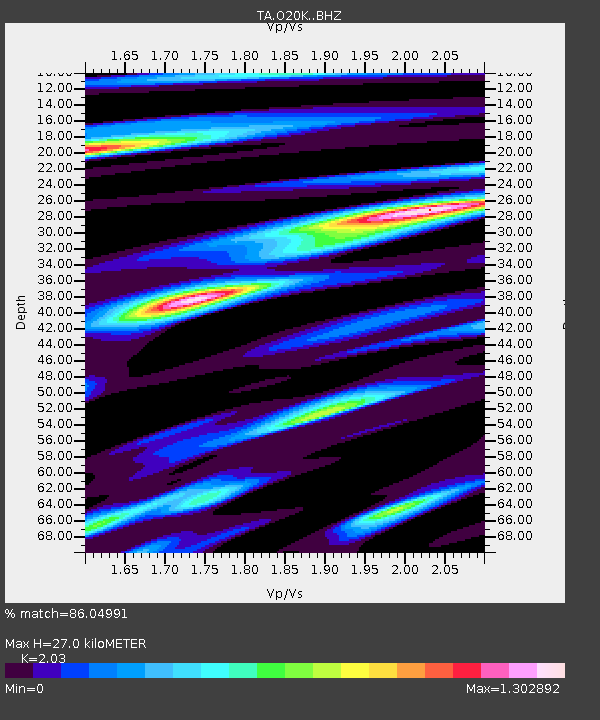
| Estimated Moho Depth: |
27.0 km |
| Estimated Crust Vp/Vs: |
2.03 |
| Assumed Crust Vp: |
6.566 km/s |
| Estimated Crust Vs: |
3.235 km/s |
| Estimated Crust Poisson's Ratio: |
0.34 |
|
| Radial Match: |
86.04991 % |
| Radial Bump: |
400 |
| Transverse Match: |
74.65325 % |
| Transverse Bump: |
400 |
| SOD ConfigId: |
13570011 |
| Insert Time: |
2019-04-28 13:28:31.043 +0000 |
| GWidth: |
2.5 |
| Max Bumps: |
400 |
| Tol: |
0.001 |
|

Signal To Noise
| Channel | StoN | STA | LTA |
| TA:O20K: :BHZ:20170808T13:30:18.29998Z | 4.6465707 | 6.543326E-7 | 1.4082055E-7 |
| TA:O20K: :BHN:20170808T13:30:18.29998Z | 1.3267752 | 1.8651272E-7 | 1.4057598E-7 |
| TA:O20K: :BHE:20170808T13:30:18.29998Z | 1.3719572 | 2.0414046E-7 | 1.4879505E-7 |
| Arrivals |
| Ps | 4.4 SECOND |
| PpPs | 12 SECOND |
| PsPs/PpSs | 16 SECOND |


