You are here: Home > Network List > TA - USArray Transportable Network (new EarthScope stations) Stations List
> Station R31K City Hall, Gustavus, AK, USA > Earthquake Result Viewer
R31K City Hall, Gustavus, AK, USA - Earthquake Result Viewer
| Earthquake location: |
Gansu, China |
| Earthquake latitude/longitude: |
33.2/103.8 |
| Earthquake time(UTC): |
2017/08/08 (220) 13:19:49 GMT |
| Earthquake Depth: |
10 km |
| Earthquake Magnitude: |
6.5 Mww |
| Earthquake Catalog/Contributor: |
NEIC PDE/us |
|
| Network: |
TA USArray Transportable Network (new EarthScope stations) |
| Station: |
R31K City Hall, Gustavus, AK, USA |
| Lat/Lon: |
58.41 N/135.74 W |
| Elevation: |
15 m |
|
| Distance: |
76.1 deg |
| Az: |
27.878 deg |
| Baz: |
311.866 deg |
| Ray Param: |
0.051221155 |
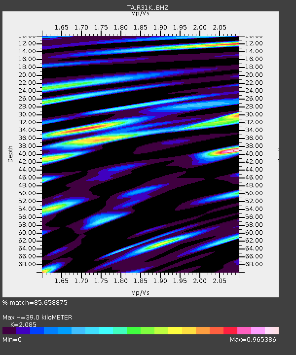
| Estimated Moho Depth: |
39.0 km |
| Estimated Crust Vp/Vs: |
2.09 |
| Assumed Crust Vp: |
6.566 km/s |
| Estimated Crust Vs: |
3.149 km/s |
| Estimated Crust Poisson's Ratio: |
0.35 |
|
| Radial Match: |
85.658875 % |
| Radial Bump: |
400 |
| Transverse Match: |
78.02649 % |
| Transverse Bump: |
400 |
| SOD ConfigId: |
13570011 |
| Insert Time: |
2019-04-28 13:28:47.507 +0000 |
| GWidth: |
2.5 |
| Max Bumps: |
400 |
| Tol: |
0.001 |
|
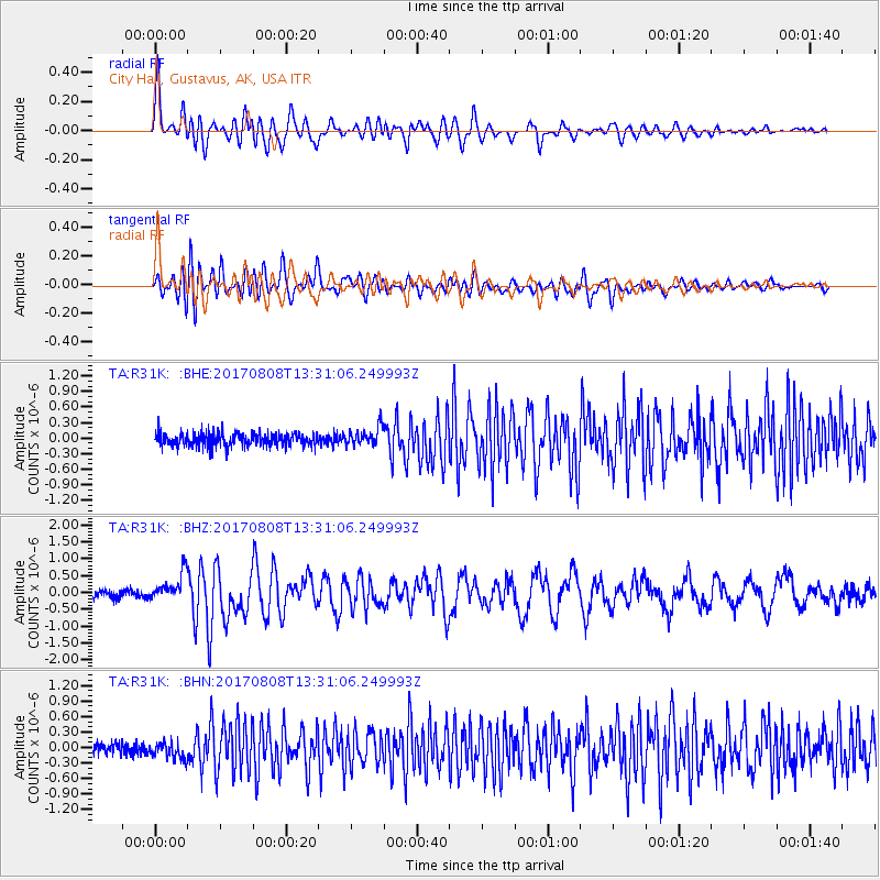
Signal To Noise
| Channel | StoN | STA | LTA |
| TA:R31K: :BHZ:20170808T13:31:06.249993Z | 3.7093678 | 4.1506644E-7 | 1.1189681E-7 |
| TA:R31K: :BHN:20170808T13:31:06.249993Z | 1.5392151 | 1.6265626E-7 | 1.05674815E-7 |
| TA:R31K: :BHE:20170808T13:31:06.249993Z | 1.3483714 | 1.7296955E-7 | 1.2828035E-7 |
| Arrivals |
| Ps | 6.6 SECOND |
| PpPs | 18 SECOND |
| PsPs/PpSs | 24 SECOND |


