You are here: Home > Network List > TA - USArray Transportable Network (new EarthScope stations) Stations List
> Station 118A Homack Ranch, Wilcox, AZ, USA > Earthquake Result Viewer
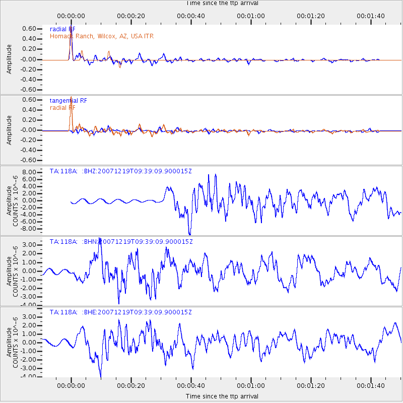
118A Homack Ranch, Wilcox, AZ, USA - Earthquake Result Viewer
| Earthquake location: |
Andreanof Islands, Aleutian Is. |
| Earthquake latitude/longitude: |
51.4/-179.5 |
| Earthquake time(UTC): |
2007/12/19 (353) 09:30:27 GMT |
| Earthquake Depth: |
29 km |
| Earthquake Magnitude: |
6.4 MB, 7.1 MS, 7.1 MW, 7.0 MW |
| Earthquake Catalog/Contributor: |
WHDF/NEIC |
|
| Network: |
TA USArray Transportable Network (new EarthScope stations) |
| Station: |
118A Homack Ranch, Wilcox, AZ, USA |
| Lat/Lon: |
32.64 N/109.97 W |
| Elevation: |
1440 m |
|
| Distance: |
52.9 deg |
| Az: |
82.299 deg |
| Baz: |
312.577 deg |
| Ray Param: |
0.06639753 |
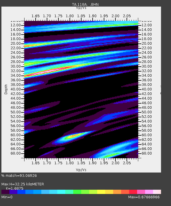
| Estimated Moho Depth: |
32.25 km |
| Estimated Crust Vp/Vs: |
1.69 |
| Assumed Crust Vp: |
6.276 km/s |
| Estimated Crust Vs: |
3.719 km/s |
| Estimated Crust Poisson's Ratio: |
0.23 |
|
| Radial Match: |
93.06926 % |
| Radial Bump: |
320 |
| Transverse Match: |
76.02762 % |
| Transverse Bump: |
400 |
| SOD ConfigId: |
2564 |
| Insert Time: |
2010-03-06 02:38:54.730 +0000 |
| GWidth: |
2.5 |
| Max Bumps: |
400 |
| Tol: |
0.001 |
|
Signal To Noise
| Channel | StoN | STA | LTA |
| TA:118A: :BHN:20071219T09:39:09.900015Z | 4.683676 | 7.134853E-7 | 1.5233448E-7 |
| TA:118A: :BHE:20071219T09:39:09.900015Z | 4.082232 | 1.0674846E-6 | 2.6149533E-7 |
| TA:118A: :BHZ:20071219T09:39:09.900015Z | 5.355069 | 2.3636278E-6 | 4.4138136E-7 |
| Arrivals |
| Ps | 3.7 SECOND |
| PpPs | 13 SECOND |
| PsPs/PpSs | 17 SECOND |


