You are here: Home > Network List > TA - USArray Transportable Network (new EarthScope stations) Stations List
> Station 118A Homack Ranch, Wilcox, AZ, USA > Earthquake Result Viewer
118A Homack Ranch, Wilcox, AZ, USA - Earthquake Result Viewer
| Earthquake location: |
Mariana Islands |
| Earthquake latitude/longitude: |
18.9/145.4 |
| Earthquake time(UTC): |
2007/10/31 (304) 03:30:17 GMT |
| Earthquake Depth: |
223 km |
| Earthquake Magnitude: |
6.2 MB, 7.2 MW, 7.2 MW |
| Earthquake Catalog/Contributor: |
WHDF/NEIC |
|
| Network: |
TA USArray Transportable Network (new EarthScope stations) |
| Station: |
118A Homack Ranch, Wilcox, AZ, USA |
| Lat/Lon: |
32.64 N/109.97 W |
| Elevation: |
1440 m |
|
| Distance: |
91.7 deg |
| Az: |
54.744 deg |
| Baz: |
293.607 deg |
| Ray Param: |
0.04146664 |
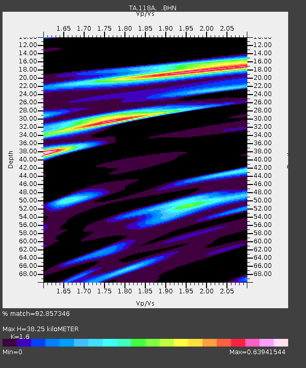
| Estimated Moho Depth: |
38.25 km |
| Estimated Crust Vp/Vs: |
1.60 |
| Assumed Crust Vp: |
6.276 km/s |
| Estimated Crust Vs: |
3.922 km/s |
| Estimated Crust Poisson's Ratio: |
0.18 |
|
| Radial Match: |
92.857346 % |
| Radial Bump: |
326 |
| Transverse Match: |
79.93838 % |
| Transverse Bump: |
400 |
| SOD ConfigId: |
2564 |
| Insert Time: |
2010-03-06 02:39:11.595 +0000 |
| GWidth: |
2.5 |
| Max Bumps: |
400 |
| Tol: |
0.001 |
|
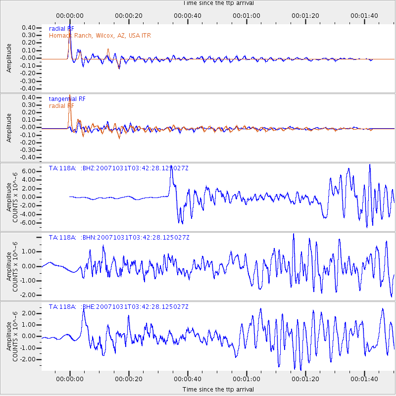
Signal To Noise
| Channel | StoN | STA | LTA |
| TA:118A: :BHN:20071031T03:42:28.125027Z | 1.4598482 | 3.4895876E-7 | 2.3903772E-7 |
| TA:118A: :BHE:20071031T03:42:28.125027Z | 5.0091186 | 7.985779E-7 | 1.5942483E-7 |
| TA:118A: :BHZ:20071031T03:42:28.125027Z | 12.832209 | 2.5995755E-6 | 2.0258207E-7 |
| Arrivals |
| Ps | 3.7 SECOND |
| PpPs | 16 SECOND |
| PsPs/PpSs | 19 SECOND |


