You are here: Home > Network List > TA - USArray Transportable Network (new EarthScope stations) Stations List
> Station 118A Homack Ranch, Wilcox, AZ, USA > Earthquake Result Viewer
118A Homack Ranch, Wilcox, AZ, USA - Earthquake Result Viewer
| Earthquake location: |
South Of Fiji Islands |
| Earthquake latitude/longitude: |
-25.8/179.5 |
| Earthquake time(UTC): |
2007/10/16 (289) 21:05:43 GMT |
| Earthquake Depth: |
509 km |
| Earthquake Magnitude: |
6.2 MB, 6.6 MW, 6.5 MW |
| Earthquake Catalog/Contributor: |
WHDF/NEIC |
|
| Network: |
TA USArray Transportable Network (new EarthScope stations) |
| Station: |
118A Homack Ranch, Wilcox, AZ, USA |
| Lat/Lon: |
32.64 N/109.97 W |
| Elevation: |
1440 m |
|
| Distance: |
88.8 deg |
| Az: |
52.704 deg |
| Baz: |
238.226 deg |
| Ray Param: |
0.04165943 |
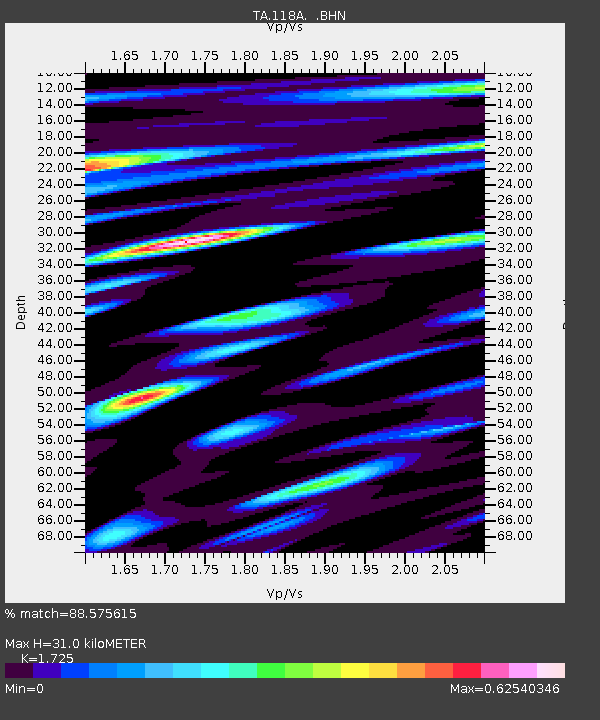
| Estimated Moho Depth: |
31.0 km |
| Estimated Crust Vp/Vs: |
1.73 |
| Assumed Crust Vp: |
6.276 km/s |
| Estimated Crust Vs: |
3.638 km/s |
| Estimated Crust Poisson's Ratio: |
0.25 |
|
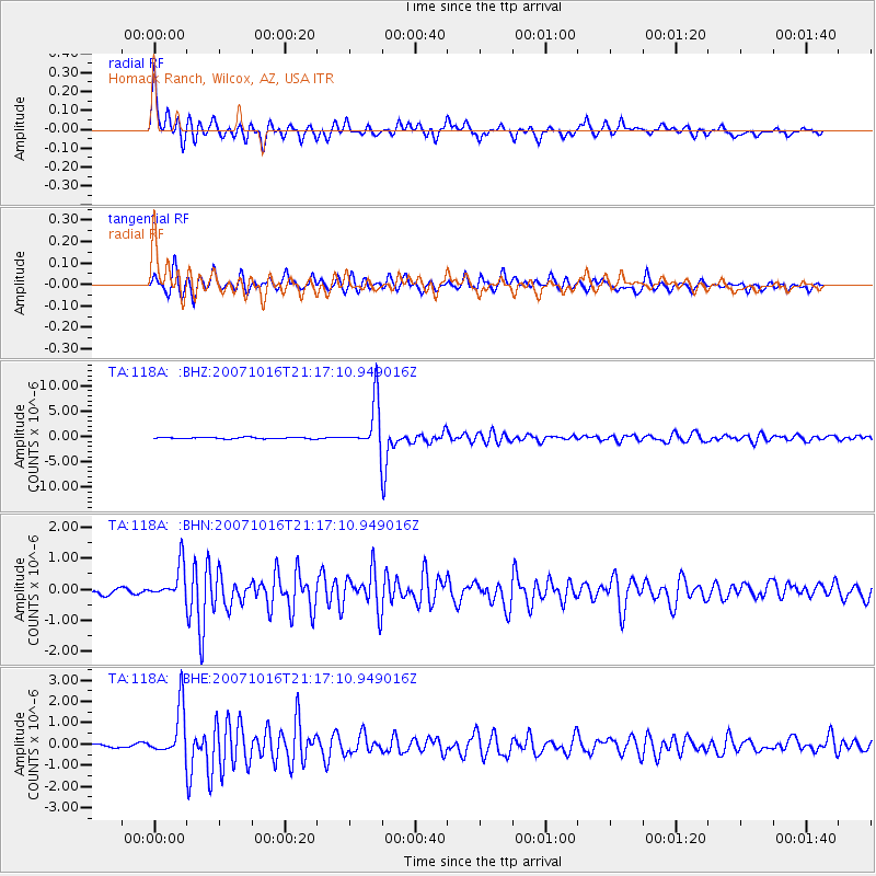
| Radial Match: |
88.575615 % |
| Radial Bump: |
361 |
| Transverse Match: |
78.92352 % |
| Transverse Bump: |
300 |
| SOD ConfigId: |
2564 |
| Insert Time: |
2010-03-06 02:39:13.638 +0000 |
| GWidth: |
2.5 |
| Max Bumps: |
400 |
| Tol: |
0.001 |
|
Signal To Noise
| Channel | StoN | STA | LTA |
| TA:118A: :BHN:20071016T21:17:10.949016Z | 5.2822948 | 5.438663E-7 | 1.0296023E-7 |
| TA:118A: :BHE:20071016T21:17:10.949016Z | 16.689764 | 1.1560743E-6 | 6.926847E-8 |
| TA:118A: :BHZ:20071016T21:17:10.949016Z | 34.423687 | 4.681196E-6 | 1.3598766E-7 |
| Arrivals |
| Ps | 3.7 SECOND |
| PpPs | 13 SECOND |
| PsPs/PpSs | 17 SECOND |


