You are here: Home > Network List > TA - USArray Transportable Network (new EarthScope stations) Stations List
> Station 118A Homack Ranch, Wilcox, AZ, USA > Earthquake Result Viewer
118A Homack Ranch, Wilcox, AZ, USA - Earthquake Result Viewer
| Earthquake location: |
Near Coast Of Peru |
| Earthquake latitude/longitude: |
-13.4/-76.6 |
| Earthquake time(UTC): |
2007/08/15 (227) 23:40:57 GMT |
| Earthquake Depth: |
39 km |
| Earthquake Magnitude: |
6.7 MB, 7.9 MS, 8.0 MW, 7.5 ME |
| Earthquake Catalog/Contributor: |
WHDF/NEIC |
|
| Network: |
TA USArray Transportable Network (new EarthScope stations) |
| Station: |
118A Homack Ranch, Wilcox, AZ, USA |
| Lat/Lon: |
32.64 N/109.97 W |
| Elevation: |
1440 m |
|
| Distance: |
55.8 deg |
| Az: |
325.865 deg |
| Baz: |
139.666 deg |
| Ray Param: |
0.06448642 |
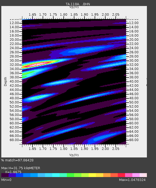
| Estimated Moho Depth: |
31.75 km |
| Estimated Crust Vp/Vs: |
1.67 |
| Assumed Crust Vp: |
6.276 km/s |
| Estimated Crust Vs: |
3.764 km/s |
| Estimated Crust Poisson's Ratio: |
0.22 |
|
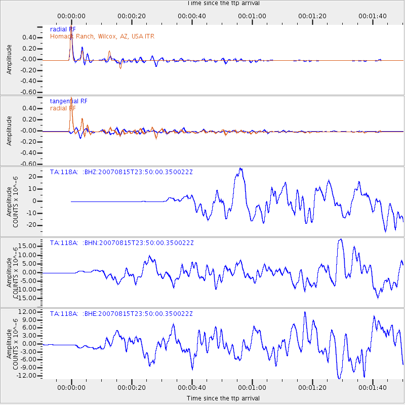
| Radial Match: |
97.86428 % |
| Radial Bump: |
343 |
| Transverse Match: |
86.217865 % |
| Transverse Bump: |
400 |
| SOD ConfigId: |
2564 |
| Insert Time: |
2010-03-06 02:39:31.817 +0000 |
| GWidth: |
2.5 |
| Max Bumps: |
400 |
| Tol: |
0.001 |
|
Signal To Noise
| Channel | StoN | STA | LTA |
| TA:118A: :BHN:20070815T23:50:00.350022Z | 16.600908 | 7.688614E-7 | 4.6314415E-8 |
| TA:118A: :BHE:20070815T23:50:00.350022Z | 11.787222 | 6.477952E-7 | 5.4957415E-8 |
| TA:118A: :BHZ:20070815T23:50:00.350022Z | 18.077648 | 1.8543011E-6 | 1.0257425E-7 |
| Arrivals |
| Ps | 3.6 SECOND |
| PpPs | 13 SECOND |
| PsPs/PpSs | 16 SECOND |


