You are here: Home > Network List > TA - USArray Transportable Network (new EarthScope stations) Stations List
> Station 118A Homack Ranch, Wilcox, AZ, USA > Earthquake Result Viewer
118A Homack Ranch, Wilcox, AZ, USA - Earthquake Result Viewer
| Earthquake location: |
Near Coast Of Central Chile |
| Earthquake latitude/longitude: |
-32.0/-71.3 |
| Earthquake time(UTC): |
2007/06/28 (179) 19:25:21 GMT |
| Earthquake Depth: |
69 km |
| Earthquake Magnitude: |
5.5 MB, 5.7 MW, 5.6 MW |
| Earthquake Catalog/Contributor: |
WHDF/NEIC |
|
| Network: |
TA USArray Transportable Network (new EarthScope stations) |
| Station: |
118A Homack Ranch, Wilcox, AZ, USA |
| Lat/Lon: |
32.64 N/109.97 W |
| Elevation: |
1440 m |
|
| Distance: |
73.9 deg |
| Az: |
326.76 deg |
| Baz: |
146.498 deg |
| Ray Param: |
0.05252763 |
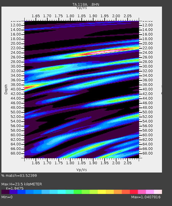
| Estimated Moho Depth: |
23.5 km |
| Estimated Crust Vp/Vs: |
1.95 |
| Assumed Crust Vp: |
6.276 km/s |
| Estimated Crust Vs: |
3.222 km/s |
| Estimated Crust Poisson's Ratio: |
0.32 |
|
| Radial Match: |
83.52399 % |
| Radial Bump: |
400 |
| Transverse Match: |
76.333664 % |
| Transverse Bump: |
400 |
| SOD ConfigId: |
2564 |
| Insert Time: |
2010-03-06 02:39:54.764 +0000 |
| GWidth: |
2.5 |
| Max Bumps: |
400 |
| Tol: |
0.001 |
|
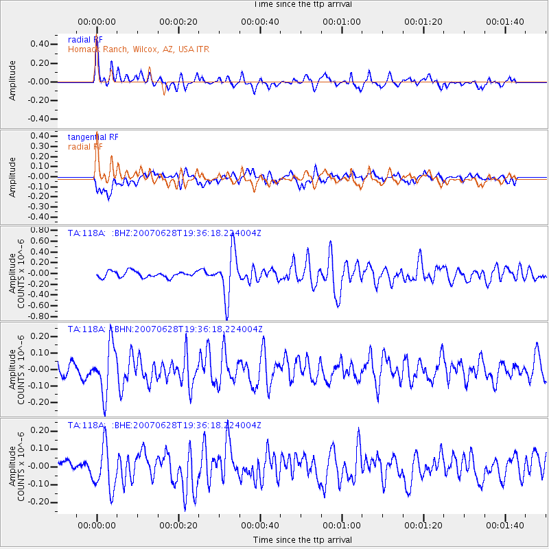
Signal To Noise
| Channel | StoN | STA | LTA |
| TA:118A: :BHN:20070628T19:36:18.224004Z | 4.9425507 | 1.5042517E-7 | 3.0434723E-8 |
| TA:118A: :BHE:20070628T19:36:18.224004Z | 3.1215966 | 1.2991238E-7 | 4.1617287E-8 |
| TA:118A: :BHZ:20070628T19:36:18.224004Z | 7.742692 | 4.3966924E-7 | 5.678506E-8 |
| Arrivals |
| Ps | 3.7 SECOND |
| PpPs | 11 SECOND |
| PsPs/PpSs | 14 SECOND |


