You are here: Home > Network List > TA - USArray Transportable Network (new EarthScope stations) Stations List
> Station 118A Homack Ranch, Wilcox, AZ, USA > Earthquake Result Viewer
118A Homack Ranch, Wilcox, AZ, USA - Earthquake Result Viewer
| Earthquake location: |
Near Coast Of Peru |
| Earthquake latitude/longitude: |
-15.7/-74.9 |
| Earthquake time(UTC): |
2007/06/28 (179) 08:44:48 GMT |
| Earthquake Depth: |
27 km |
| Earthquake Magnitude: |
5.5 MB, 5.3 MS, 5.8 MW, 5.8 MW |
| Earthquake Catalog/Contributor: |
WHDF/NEIC |
|
| Network: |
TA USArray Transportable Network (new EarthScope stations) |
| Station: |
118A Homack Ranch, Wilcox, AZ, USA |
| Lat/Lon: |
32.64 N/109.97 W |
| Elevation: |
1440 m |
|
| Distance: |
58.6 deg |
| Az: |
325.387 deg |
| Baz: |
139.573 deg |
| Ray Param: |
0.06268944 |
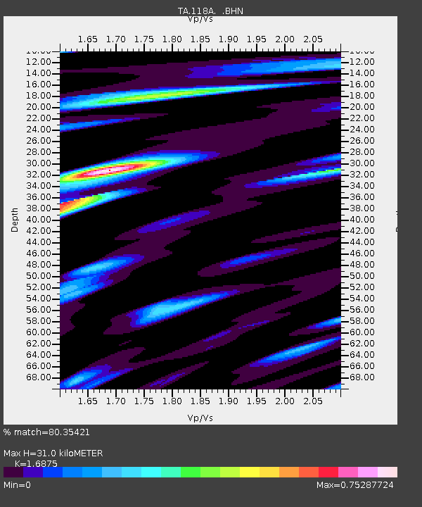
| Estimated Moho Depth: |
31.0 km |
| Estimated Crust Vp/Vs: |
1.69 |
| Assumed Crust Vp: |
6.276 km/s |
| Estimated Crust Vs: |
3.719 km/s |
| Estimated Crust Poisson's Ratio: |
0.23 |
|
| Radial Match: |
80.35421 % |
| Radial Bump: |
400 |
| Transverse Match: |
76.54296 % |
| Transverse Bump: |
400 |
| SOD ConfigId: |
2564 |
| Insert Time: |
2010-03-06 02:39:56.442 +0000 |
| GWidth: |
2.5 |
| Max Bumps: |
400 |
| Tol: |
0.001 |
|
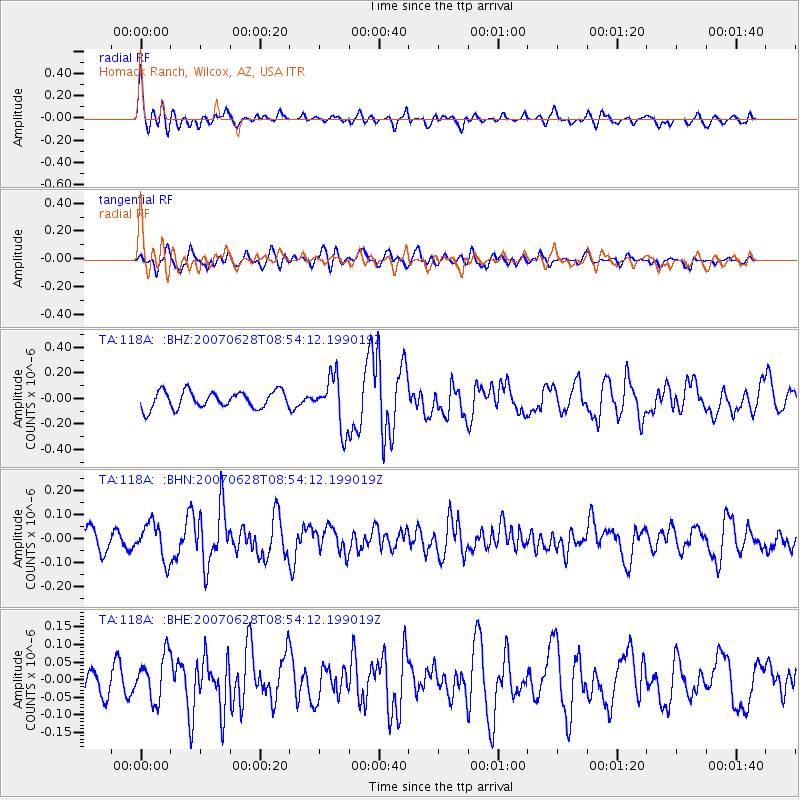
Signal To Noise
| Channel | StoN | STA | LTA |
| TA:118A: :BHN:20070628T08:54:12.199019Z | 1.9536695 | 7.51908E-8 | 3.848696E-8 |
| TA:118A: :BHE:20070628T08:54:12.199019Z | 1.7104666 | 6.351161E-8 | 3.713116E-8 |
| TA:118A: :BHZ:20070628T08:54:12.199019Z | 3.0069163 | 1.9957778E-7 | 6.637291E-8 |
| Arrivals |
| Ps | 3.6 SECOND |
| PpPs | 13 SECOND |
| PsPs/PpSs | 16 SECOND |


