You are here: Home > Network List > TA - USArray Transportable Network (new EarthScope stations) Stations List
> Station 118A Homack Ranch, Wilcox, AZ, USA > Earthquake Result Viewer
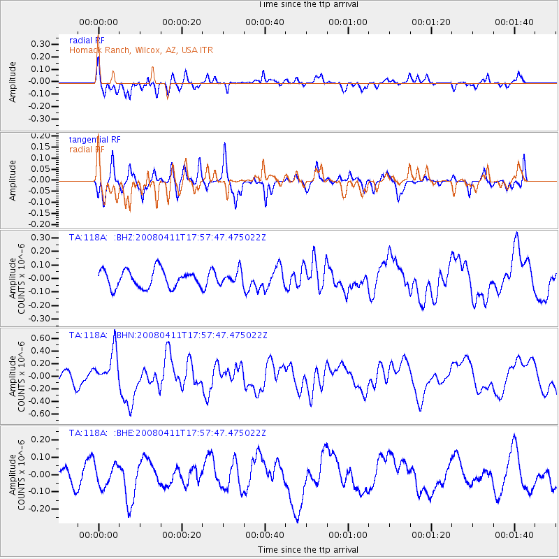
118A Homack Ranch, Wilcox, AZ, USA - Earthquake Result Viewer
*The percent match for this event was below the threshold and hence no stack was calculated.
| Earthquake location: |
Loyalty Islands |
| Earthquake latitude/longitude: |
-20.4/168.8 |
| Earthquake time(UTC): |
2008/04/11 (102) 17:45:05 GMT |
| Earthquake Depth: |
35 km |
| Earthquake Magnitude: |
5.7 MB, 5.9 MS, 6.0 MW, 6.0 MW |
| Earthquake Catalog/Contributor: |
WHDF/NEIC |
|
| Network: |
TA USArray Transportable Network (new EarthScope stations) |
| Station: |
118A Homack Ranch, Wilcox, AZ, USA |
| Lat/Lon: |
32.64 N/109.97 W |
| Elevation: |
1440 m |
|
| Distance: |
93.7 deg |
| Az: |
56.677 deg |
| Baz: |
248.276 deg |
| Ray Param: |
$rayparam |
*The percent match for this event was below the threshold and hence was not used in the summary stack. |
|
| Radial Match: |
54.453075 % |
| Radial Bump: |
328 |
| Transverse Match: |
58.12801 % |
| Transverse Bump: |
352 |
| SOD ConfigId: |
2504 |
| Insert Time: |
2010-03-06 02:40:33.316 +0000 |
| GWidth: |
2.5 |
| Max Bumps: |
400 |
| Tol: |
0.001 |
|
Signal To Noise
| Channel | StoN | STA | LTA |
| TA:118A: :BHN:20080411T17:57:47.475022Z | 2.9972935 | 2.8959738E-7 | 9.661963E-8 |
| TA:118A: :BHE:20080411T17:57:47.475022Z | 1.0338321 | 6.0546164E-8 | 5.8564794E-8 |
| TA:118A: :BHZ:20080411T17:57:47.475022Z | 0.7651914 | 4.959869E-8 | 6.481868E-8 |
| Arrivals |
| Ps | |
| PpPs | |
| PsPs/PpSs | |


