You are here: Home > Network List > NE - New England Seismic Network Stations List
> Station WSPT Westport, CT, USA > Earthquake Result Viewer
WSPT Westport, CT, USA - Earthquake Result Viewer
| Earthquake location: |
Southern Alaska |
| Earthquake latitude/longitude: |
59.7/-153.5 |
| Earthquake time(UTC): |
2016/01/24 (024) 10:30:30 GMT |
| Earthquake Depth: |
128 km |
| Earthquake Magnitude: |
7.1 MWW, 6.4 ML |
| Earthquake Catalog/Contributor: |
NEIC PDE/NEIC COMCAT |
|
| Network: |
NE New England Seismic Network |
| Station: |
WSPT Westport, CT, USA |
| Lat/Lon: |
41.17 N/73.33 W |
| Elevation: |
91 m |
|
| Distance: |
50.9 deg |
| Az: |
73.424 deg |
| Baz: |
319.869 deg |
| Ray Param: |
0.06733868 |
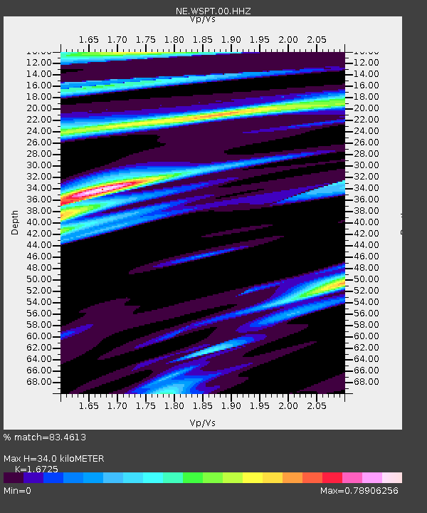
| Estimated Moho Depth: |
34.0 km |
| Estimated Crust Vp/Vs: |
1.67 |
| Assumed Crust Vp: |
6.472 km/s |
| Estimated Crust Vs: |
3.87 km/s |
| Estimated Crust Poisson's Ratio: |
0.22 |
|
| Radial Match: |
83.4613 % |
| Radial Bump: |
351 |
| Transverse Match: |
46.788498 % |
| Transverse Bump: |
391 |
| SOD ConfigId: |
1399611 |
| Insert Time: |
2016-02-07 11:08:26.299 +0000 |
| GWidth: |
2.5 |
| Max Bumps: |
400 |
| Tol: |
0.001 |
|

Signal To Noise
| Channel | StoN | STA | LTA |
| NE:WSPT:00:HHZ:20160124T10:38:47.498986Z | 1.5340306 | 2.7797012E-6 | 1.8120246E-6 |
| NE:WSPT:00:HH1:20160124T10:38:47.498986Z | 0.6058554 | 1.0760212E-6 | 1.7760364E-6 |
| NE:WSPT:00:HH2:20160124T10:38:47.498986Z | 5.4792857 | 3.3689894E-6 | 6.148592E-7 |
| Arrivals |
| Ps | 3.8 SECOND |
| PpPs | 13 SECOND |
| PsPs/PpSs | 17 SECOND |


