You are here: Home > Network List > NM - Cooperative New Madrid Seismic Network Stations List
> Station HALT Halls,TN > Earthquake Result Viewer
HALT Halls,TN - Earthquake Result Viewer
| Earthquake location: |
Southern Alaska |
| Earthquake latitude/longitude: |
59.7/-153.5 |
| Earthquake time(UTC): |
2016/01/24 (024) 10:30:30 GMT |
| Earthquake Depth: |
128 km |
| Earthquake Magnitude: |
7.1 MWW, 6.4 ML |
| Earthquake Catalog/Contributor: |
NEIC PDE/NEIC COMCAT |
|
| Network: |
NM Cooperative New Madrid Seismic Network |
| Station: |
HALT Halls,TN |
| Lat/Lon: |
35.91 N/89.34 W |
| Elevation: |
85 m |
|
| Distance: |
46.9 deg |
| Az: |
90.699 deg |
| Baz: |
321.293 deg |
| Ray Param: |
0.06987622 |
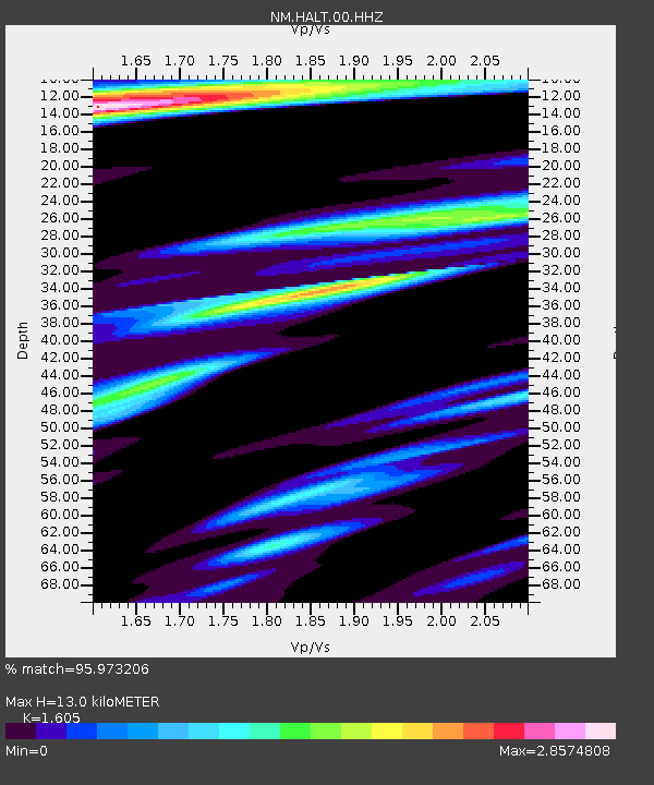
| Estimated Moho Depth: |
13.0 km |
| Estimated Crust Vp/Vs: |
1.61 |
| Assumed Crust Vp: |
6.38 km/s |
| Estimated Crust Vs: |
3.975 km/s |
| Estimated Crust Poisson's Ratio: |
0.18 |
|
| Radial Match: |
95.973206 % |
| Radial Bump: |
400 |
| Transverse Match: |
80.23354 % |
| Transverse Bump: |
400 |
| SOD ConfigId: |
1399611 |
| Insert Time: |
2016-02-07 11:08:40.255 +0000 |
| GWidth: |
2.5 |
| Max Bumps: |
400 |
| Tol: |
0.001 |
|

Signal To Noise
| Channel | StoN | STA | LTA |
| NM:HALT:00:HHZ:20160124T10:38:17.235009Z | 2.5137694 | 2.6127107E-6 | 1.0393597E-6 |
| NM:HALT:00:HHN:20160124T10:38:17.235009Z | 1.5287273 | 2.234389E-6 | 1.4616007E-6 |
| NM:HALT:00:HHE:20160124T10:38:17.235009Z | 0.4947875 | 9.891467E-7 | 1.9991344E-6 |
| Arrivals |
| Ps | 1.3 SECOND |
| PpPs | 5.0 SECOND |
| PsPs/PpSs | 6.3 SECOND |


