You are here: Home > Network List > TA - USArray Transportable Network (new EarthScope stations) Stations List
> Station A18A Metzger Ranch, Havre, MT, USA > Earthquake Result Viewer
A18A Metzger Ranch, Havre, MT, USA - Earthquake Result Viewer

| Earthquake location: |
Kuril Islands |
| Earthquake latitude/longitude: |
46.0/151.5 |
| Earthquake time(UTC): |
2009/04/07 (097) 04:23:33 GMT |
| Earthquake Depth: |
31 km |
| Earthquake Magnitude: |
6.5 MB, 6.8 MS, 6.9 MW, 6.9 MW |
| Earthquake Catalog/Contributor: |
WHDF/NEIC |
|
| Network: |
TA USArray Transportable Network (new EarthScope stations) |
| Station: |
A18A Metzger Ranch, Havre, MT, USA |
| Lat/Lon: |
48.92 N/109.85 W |
| Elevation: |
804 m |
|
| Distance: |
61.9 deg |
| Az: |
47.66 deg |
| Baz: |
308.699 deg |
| Ray Param: |
0.060514215 |
| Estimated Moho Depth: |
52.75 km |
| Estimated Crust Vp/Vs: |
1.66 |
| Assumed Crust Vp: |
6.438 km/s |
| Estimated Crust Vs: |
3.866 km/s |
| Estimated Crust Poisson's Ratio: |
0.22 |
|
| Radial Match: |
94.413315 % |
| Radial Bump: |
391 |
| Transverse Match: |
83.82891 % |
| Transverse Bump: |
400 |
| SOD ConfigId: |
2658 |
| Insert Time: |
2010-03-06 02:41:13.026 +0000 |
| GWidth: |
2.5 |
| Max Bumps: |
400 |
| Tol: |
0.001 |
|
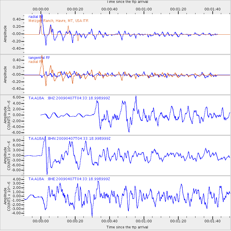
Signal To Noise
| Channel | StoN | STA | LTA |
| TA:A18A: :BHN:20090407T04:33:18.998999Z | 34.61806 | 6.252224E-6 | 1.8060584E-7 |
| TA:A18A: :BHE:20090407T04:33:18.998999Z | 2.9162674 | 1.6220033E-6 | 5.5619154E-7 |
| TA:A18A: :BHZ:20090407T04:33:18.998999Z | 5.8610053 | 2.655476E-6 | 4.5307516E-7 |
| Arrivals |
| Ps | 5.7 SECOND |
| PpPs | 21 SECOND |
| PsPs/PpSs | 27 SECOND |


