You are here: Home > Network List > NO - Norwegian Seismic Array Network Stations List
> Station SPB5 > Earthquake Result Viewer
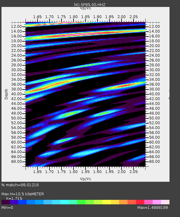
SPB5 - Earthquake Result Viewer
| Earthquake location: |
Southern Alaska |
| Earthquake latitude/longitude: |
59.7/-153.5 |
| Earthquake time(UTC): |
2016/01/24 (024) 10:30:30 GMT |
| Earthquake Depth: |
128 km |
| Earthquake Magnitude: |
7.1 MWW, 6.4 ML |
| Earthquake Catalog/Contributor: |
NEIC PDE/NEIC COMCAT |
|
| Network: |
NO Norwegian Seismic Array Network |
| Station: |
SPB5 |
| Lat/Lon: |
78.18 N/16.37 E |
| Elevation: |
295 m |
|
| Distance: |
42.3 deg |
| Az: |
3.105 deg |
| Baz: |
352.333 deg |
| Ray Param: |
0.07283028 |
| Estimated Moho Depth: |
10.5 km |
| Estimated Crust Vp/Vs: |
1.72 |
| Assumed Crust Vp: |
6.545 km/s |
| Estimated Crust Vs: |
3.817 km/s |
| Estimated Crust Poisson's Ratio: |
0.24 |
|
| Radial Match: |
89.01218 % |
| Radial Bump: |
400 |
| Transverse Match: |
82.00715 % |
| Transverse Bump: |
400 |
| SOD ConfigId: |
1399611 |
| Insert Time: |
2016-02-07 11:09:33.811 +0000 |
| GWidth: |
2.5 |
| Max Bumps: |
400 |
| Tol: |
0.001 |
|

Signal To Noise
| Channel | StoN | STA | LTA |
| NO:SPB5:00:HHZ:20160124T10:37:40.386986Z | 5.5138054 | 8.877177E-7 | 1.609991E-7 |
| NO:SPB5:00:HHN:20160124T10:37:40.386986Z | 2.1569219 | 3.7610508E-7 | 1.7437121E-7 |
| NO:SPB5:00:HHE:20160124T10:37:40.386986Z | 1.2074256 | 2.5534027E-7 | 2.1147494E-7 |
| Arrivals |
| Ps | 1.2 SECOND |
| PpPs | 4.1 SECOND |
| PsPs/PpSs | 5.3 SECOND |


