You are here: Home > Network List > TA - USArray Transportable Network (new EarthScope stations) Stations List
> Station A18A Metzger Ranch, Havre, MT, USA > Earthquake Result Viewer
A18A Metzger Ranch, Havre, MT, USA - Earthquake Result Viewer
| Earthquake location: |
Sichuan, China |
| Earthquake latitude/longitude: |
31.0/103.3 |
| Earthquake time(UTC): |
2008/05/12 (133) 06:28:01 GMT |
| Earthquake Depth: |
19 km |
| Earthquake Magnitude: |
6.9 MB, 8.1 MS, 7.9 MW, 7.9 MW |
| Earthquake Catalog/Contributor: |
WHDF/NEIC |
|
| Network: |
TA USArray Transportable Network (new EarthScope stations) |
| Station: |
A18A Metzger Ranch, Havre, MT, USA |
| Lat/Lon: |
48.92 N/109.85 W |
| Elevation: |
804 m |
|
| Distance: |
95.1 deg |
| Az: |
21.242 deg |
| Baz: |
331.859 deg |
| Ray Param: |
0.04086677 |
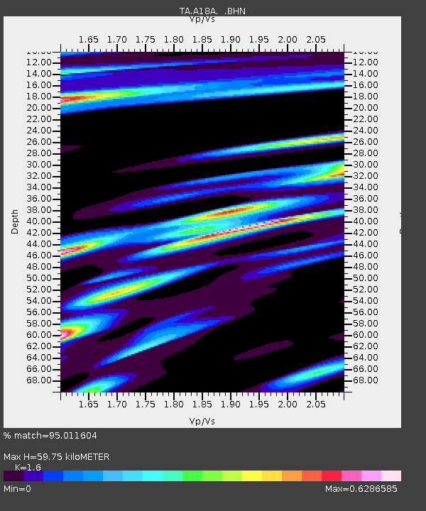
| Estimated Moho Depth: |
59.75 km |
| Estimated Crust Vp/Vs: |
1.60 |
| Assumed Crust Vp: |
6.438 km/s |
| Estimated Crust Vs: |
4.023 km/s |
| Estimated Crust Poisson's Ratio: |
0.18 |
|
| Radial Match: |
95.011604 % |
| Radial Bump: |
280 |
| Transverse Match: |
84.81176 % |
| Transverse Bump: |
356 |
| SOD ConfigId: |
2504 |
| Insert Time: |
2010-03-06 02:41:22.319 +0000 |
| GWidth: |
2.5 |
| Max Bumps: |
400 |
| Tol: |
0.001 |
|
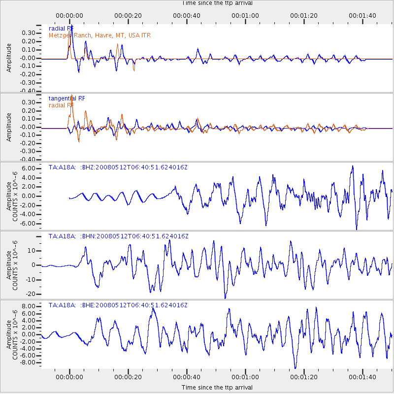
Signal To Noise
| Channel | StoN | STA | LTA |
| TA:A18A: :BHN:20080512T06:40:51.624016Z | 12.784993 | 2.625902E-6 | 2.0538938E-7 |
| TA:A18A: :BHE:20080512T06:40:51.624016Z | 1.3493212 | 8.1577747E-7 | 6.045836E-7 |
| TA:A18A: :BHZ:20080512T06:40:51.624016Z | 0.6527296 | 4.3721369E-7 | 6.6982363E-7 |
| Arrivals |
| Ps | 5.7 SECOND |
| PpPs | 24 SECOND |
| PsPs/PpSs | 29 SECOND |


