You are here: Home > Network List > NN - Western Great Basin/Eastern Sierra Nevada Stations List
> Station OMMB Old Mammoth Mine, surface, wgs-84 > Earthquake Result Viewer
OMMB Old Mammoth Mine, surface, wgs-84 - Earthquake Result Viewer
| Earthquake location: |
Northern Xinjiang, China |
| Earthquake latitude/longitude: |
44.3/82.8 |
| Earthquake time(UTC): |
2017/08/08 (220) 23:27:53 GMT |
| Earthquake Depth: |
20 km |
| Earthquake Magnitude: |
6.3 Mww |
| Earthquake Catalog/Contributor: |
NEIC PDE/us |
|
| Network: |
NN Western Great Basin/Eastern Sierra Nevada |
| Station: |
OMMB Old Mammoth Mine, surface, wgs-84 |
| Lat/Lon: |
37.61 N/119.00 W |
| Elevation: |
2768 m |
|
| Distance: |
96.1 deg |
| Az: |
17.281 deg |
| Baz: |
344.421 deg |
| Ray Param: |
0.040601656 |
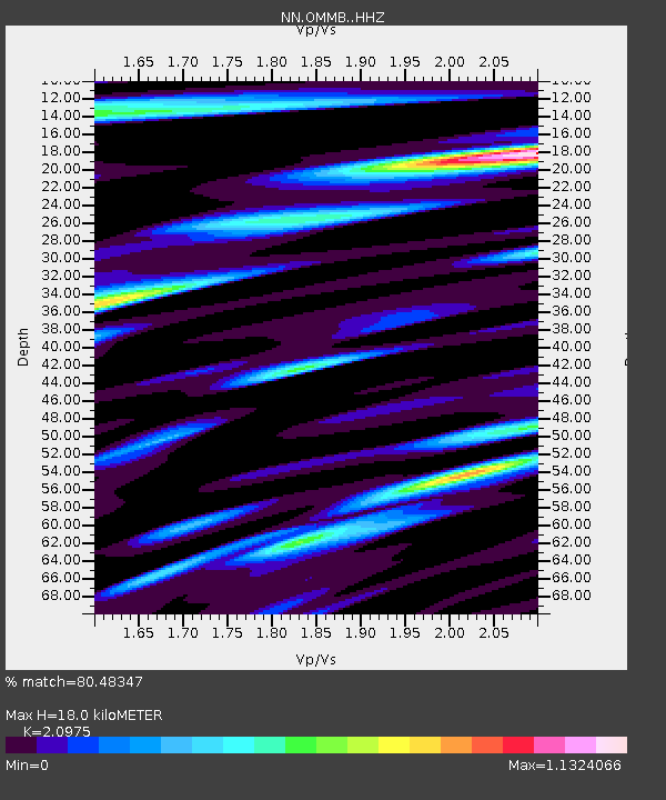
| Estimated Moho Depth: |
18.0 km |
| Estimated Crust Vp/Vs: |
2.10 |
| Assumed Crust Vp: |
6.291 km/s |
| Estimated Crust Vs: |
2.999 km/s |
| Estimated Crust Poisson's Ratio: |
0.35 |
|
| Radial Match: |
80.48347 % |
| Radial Bump: |
400 |
| Transverse Match: |
82.58183 % |
| Transverse Bump: |
400 |
| SOD ConfigId: |
13570011 |
| Insert Time: |
2019-04-28 13:37:24.979 +0000 |
| GWidth: |
2.5 |
| Max Bumps: |
400 |
| Tol: |
0.001 |
|

Signal To Noise
| Channel | StoN | STA | LTA |
| NN:OMMB: :HHZ:20170808T23:40:47.509983Z | 3.0579312 | 1.6549652E-7 | 5.4120417E-8 |
| NN:OMMB: :HHN:20170808T23:40:47.509983Z | 1.3099481 | 5.2283376E-8 | 3.9912557E-8 |
| NN:OMMB: :HHE:20170808T23:40:47.509983Z | 0.8037532 | 3.189684E-8 | 3.9684867E-8 |
| Arrivals |
| Ps | 3.2 SECOND |
| PpPs | 8.7 SECOND |
| PsPs/PpSs | 12 SECOND |


