You are here: Home > Network List > TA - USArray Transportable Network (new EarthScope stations) Stations List
> Station A18A Metzger Ranch, Havre, MT, USA > Earthquake Result Viewer
A18A Metzger Ranch, Havre, MT, USA - Earthquake Result Viewer
| Earthquake location: |
Sea Of Okhotsk |
| Earthquake latitude/longitude: |
53.9/152.9 |
| Earthquake time(UTC): |
2008/07/05 (187) 02:12:04 GMT |
| Earthquake Depth: |
633 km |
| Earthquake Magnitude: |
6.8 MB, 7.7 MW, 7.7 MW |
| Earthquake Catalog/Contributor: |
WHDF/NEIC |
|
| Network: |
TA USArray Transportable Network (new EarthScope stations) |
| Station: |
A18A Metzger Ranch, Havre, MT, USA |
| Lat/Lon: |
48.92 N/109.85 W |
| Elevation: |
804 m |
|
| Distance: |
56.2 deg |
| Az: |
51.945 deg |
| Baz: |
315.03 deg |
| Ray Param: |
0.061550308 |
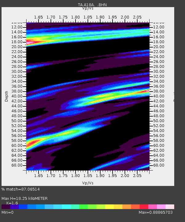
| Estimated Moho Depth: |
18.25 km |
| Estimated Crust Vp/Vs: |
1.60 |
| Assumed Crust Vp: |
6.438 km/s |
| Estimated Crust Vs: |
4.023 km/s |
| Estimated Crust Poisson's Ratio: |
0.18 |
|
| Radial Match: |
87.06514 % |
| Radial Bump: |
396 |
| Transverse Match: |
84.18728 % |
| Transverse Bump: |
400 |
| SOD ConfigId: |
2504 |
| Insert Time: |
2010-03-06 02:41:30.372 +0000 |
| GWidth: |
2.5 |
| Max Bumps: |
400 |
| Tol: |
0.001 |
|
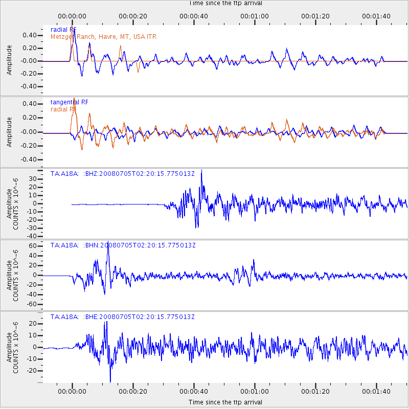
Signal To Noise
| Channel | StoN | STA | LTA |
| TA:A18A: :BHN:20080705T02:20:15.775013Z | 69.347786 | 1.068593E-5 | 1.5409186E-7 |
| TA:A18A: :BHE:20080705T02:20:15.775013Z | 14.946248 | 2.8446689E-6 | 1.9032662E-7 |
| TA:A18A: :BHZ:20080705T02:20:15.775013Z | 22.071358 | 3.880123E-6 | 1.7579903E-7 |
| Arrivals |
| Ps | 1.8 SECOND |
| PpPs | 7.0 SECOND |
| PsPs/PpSs | 8.8 SECOND |


